IMAGES TAKEN NEAR TO
Gorse Meadow, WHITCHURCH, SY13 2JF
Introduction
This page details the photographs taken nearby to Gorse Meadow, SY13 2JF by members of the Geograph project.
The Geograph project started in 2005 with the aim of publishing, organising and preserving representative images for every square kilometre of Great Britain, Ireland and the Isle of Man.

There are currently over 7.5m images from over14,400 individuals and you can help contribute to the project by visiting https://www.geograph.org.uk
Image Map (Loading...)


Getting Data...Please wait
Leaflet Map data © OpenStreetMap
Images are licensed for reuse under creativecommons.org/licenses/by-sa/2.0
Notes
- Clicking on the map will re-center to the selected point.
- The higher the marker number, the further away the image location is from the centre of the postcode.
Image Listing (29 Images Found)
Images are licensed for reuse under creativecommons.org/licenses/by-sa/2.0
Image
Details
Distance
1
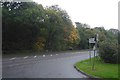
A41, Prees Higher Heath
Twemlows Big Wood on the other side.
Image: © Richard Webb
Taken: 11 Oct 2017
0.07 miles
2
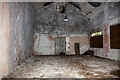
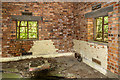
WWII Shropshire, RAF Tilstock - technical site building (2)
This interior shot reveals more of the building's construction than the previous exterior view. It may have been a store room, possibly a fabric store. Note the solitary light fitting.
Image
Image: © Mike Searle
Taken: 20 Jun 2019
0.08 miles
3
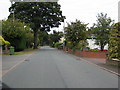
Heathwood Road joins the A41
The A41 end of Heathwood Road
Image: © Peter Fleming
Taken: 13 Sep 2007
0.08 miles
5
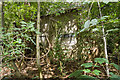
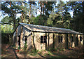
WWII Shropshire, RAF Tilstock - technical site building (1)
An unidentified building almost entirely hidden behind encroaching vegetation.
Image
Image: © Mike Searle
Taken: 20 Jun 2019
0.14 miles
6
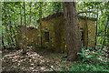
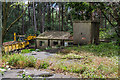
WWII Shropshire, RAF Tilstock - technical site pumphouse (1)
Borehole pumphouse for fresh water.
Image
Image: © Mike Searle
Taken: 20 Jun 2019
0.14 miles
7
WWII Shropshire, RAF Tilstock - technical site pumphouse (2)
-
Image
Image: © Mike Searle
Taken: 20 Jun 2019
0.14 miles
8
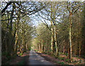
Track through Twemlows Big Wood
Metalled track from the A41 to Twemlows Cottages and The Twemlows. The woodland to the north (left) of the track is predominantly conifers, that to the south (right) is mixed, mainly deciduous
Image: © Espresso Addict
Taken: 6 May 2008
0.15 miles
9
Derelict building in Twemlows Big Wood: close up
Closer view of the building shown in Image
Image: © Espresso Addict
Taken: 6 May 2008
0.18 miles
10
WWII Shropshire, RAF Tilstock - technical site Operations Block (4)
Another view from the Ops Block roof.
Image
Image: © Mike Searle
Taken: 20 Jun 2019
0.18 miles