IMAGES TAKEN NEAR TO
Lighteach Road, WHITCHURCH, SY13 2ET
Introduction
This page details the photographs taken nearby to Lighteach Road, SY13 2ET by members of the Geograph project.
The Geograph project started in 2005 with the aim of publishing, organising and preserving representative images for every square kilometre of Great Britain, Ireland and the Isle of Man.

There are currently over 7.5m images from over14,400 individuals and you can help contribute to the project by visiting https://www.geograph.org.uk
Image Map
Images are licensed for reuse under creativecommons.org/licenses/by-sa/2.0
Notes
- Clicking on the map will re-center to the selected point.
- The higher the marker number, the further away the image location is from the centre of the postcode.
Image Listing (7 Images Found)
Images are licensed for reuse under creativecommons.org/licenses/by-sa/2.0
Image
Details
Distance
1
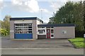
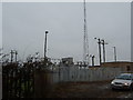
Prees fire station
Prees fire station, Brades Road, Prees, Shropshire.
Image: © Kevin Hale
Taken: 21 Oct 2006
0.12 miles
2
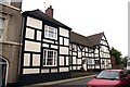
Another old building in Prees
It doesn't really show in the photo, but the building looks a bit wonky in real life.
Image: © Peter Craine
Taken: 22 Jul 2007
0.19 miles
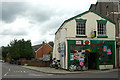
4
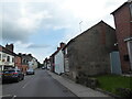
Shrewsbury Street at crossroads in village
Image: © Colin Pyle
Taken: 29 Oct 2014
0.22 miles
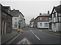
5
Part of the main street in Prees, Shropshire
Prees seems to have lots of variety architecturally and historically.
Image: © Jeremy Bolwell
Taken: 8 Jul 2021
0.23 miles
7
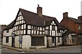
Old building in Prees
Prees is an ancient village, probably known to the Romans but settled by Saxons in the 6-7th centuries. Several of the buildings look 2 or 3 hundred years old.
Image: © Peter Craine
Taken: 22 Jul 2007
0.25 miles