IMAGES TAKEN NEAR TO
Prees Green, WHITCHURCH, SY13 2BP
Introduction
This page details the photographs taken nearby to SY13 2BP by members of the Geograph project.
The Geograph project started in 2005 with the aim of publishing, organising and preserving representative images for every square kilometre of Great Britain, Ireland and the Isle of Man.

There are currently over 7.5m images from over14,400 individuals and you can help contribute to the project by visiting https://www.geograph.org.uk
Image Map
Images are licensed for reuse under creativecommons.org/licenses/by-sa/2.0
Notes
- Clicking on the map will re-center to the selected point.
- The higher the marker number, the further away the image location is from the centre of the postcode.
Image Listing (13 Images Found)
Images are licensed for reuse under creativecommons.org/licenses/by-sa/2.0
Image
Details
Distance
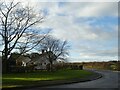
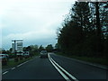
2
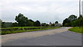
Wide bend on the A49
A bus is approaching from Prees Green, heading towards Shrewsbury.
Image: © Jonathan Billinger
Taken: 9 Sep 2015
0.04 miles
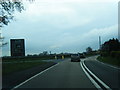
3
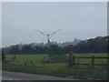
Aerials nr the B5065/A49 Junction
The Marker beacon site, part of the Instrument Landing System for RAF Shawbury
Image: © Mike Farmer
Taken: 21 Nov 2005
0.07 miles
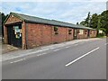
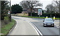
6

B5065 junction for Wem at Prees Green
Image: © Peter Whatley
Taken: 23 Mar 2012
0.13 miles