IMAGES TAKEN NEAR TO
Fauls, WHITCHURCH, SY13 2BB
Introduction
This page details the photographs taken nearby to SY13 2BB by members of the Geograph project.
The Geograph project started in 2005 with the aim of publishing, organising and preserving representative images for every square kilometre of Great Britain, Ireland and the Isle of Man.

There are currently over 7.5m images from over14,400 individuals and you can help contribute to the project by visiting https://www.geograph.org.uk
Image Map (Loading...)


Getting Data...Please wait
Leaflet Map data © OpenStreetMap
Images are licensed for reuse under creativecommons.org/licenses/by-sa/2.0
Notes
- Clicking on the map will re-center to the selected point.
- The higher the marker number, the further away the image location is from the centre of the postcode.
Image Listing (4 Images Found)
Images are licensed for reuse under creativecommons.org/licenses/by-sa/2.0
Image
Details
Distance
1
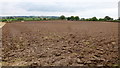
Ploughed-up stubble near Mickley
Looking south-west.
Image: © Jonathan Billinger
Taken: 9 Sep 2015
0.16 miles
2
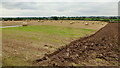
Partly-ploughed field
The plough line is parallel to the line of a footpath south from Mickley Lane.
Image: © Jonathan Billinger
Taken: 9 Sep 2015
0.19 miles
3
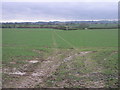
Double Path
These tyre tracks mark the line of a somewhat univiting footpath.
Image: © Michael Patterson
Taken: 22 Feb 2007
0.21 miles
4
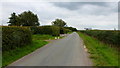
Mickley Lane
Looking east past Upper Mickley.
Image: © Jonathan Billinger
Taken: 9 Sep 2015
0.24 miles