IMAGES TAKEN NEAR TO
Heath Road, WHITCHURCH, SY13 2AD
Introduction
This page details the photographs taken nearby to Heath Road, SY13 2AD by members of the Geograph project.
The Geograph project started in 2005 with the aim of publishing, organising and preserving representative images for every square kilometre of Great Britain, Ireland and the Isle of Man.

There are currently over 7.5m images from over14,400 individuals and you can help contribute to the project by visiting https://www.geograph.org.uk
Image Map
Images are licensed for reuse under creativecommons.org/licenses/by-sa/2.0
Notes
- Clicking on the map will re-center to the selected point.
- The higher the marker number, the further away the image location is from the centre of the postcode.
Image Listing (7 Images Found)
Images are licensed for reuse under creativecommons.org/licenses/by-sa/2.0
Image
Details
Distance
1
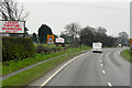
A41 at Heath Road House Farm
Signs indicate lanes to be used ahead for Whitchurch town centre or the bypass.
Image: © Peter Whatley
Taken: 17 Jan 2012
0.12 miles
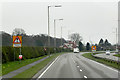
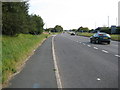
2
Get In Lane
Advice on the short dual carriageway section of the conjoined A41/A49 south of Whitchurch. Northbound A41/A49 traffic benefits from a slip lane at the roundabout ahead, though lane 2 can also access the through route via the roundabout. The A525 signage is misleading for eastbound traffic which has a shorter route via the original A41 route (now B5395).
Image: © Peter Whatley
Taken: 23 Mar 2012
0.13 miles
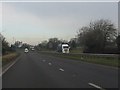
3
Traffic speeding along the A41
Traffic motoring along the dual carriageway
Image: © Peter Fleming
Taken: 13 Sep 2007
0.18 miles
4
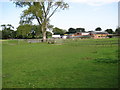
Heathlane
Farm buildings beside the A41
Image: © Peter Fleming
Taken: 13 Sep 2007
0.19 miles
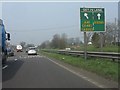
5
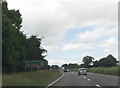
A41 at Heathlane
Approaching roundabout at start of Whitchurch bypass
Image: © John Firth
Taken: 15 Jun 2013
0.19 miles