IMAGES TAKEN NEAR TO
Wayland Road, WHITCHURCH, SY13 1RP
Introduction
This page details the photographs taken nearby to Wayland Road, SY13 1RP by members of the Geograph project.
The Geograph project started in 2005 with the aim of publishing, organising and preserving representative images for every square kilometre of Great Britain, Ireland and the Isle of Man.

There are currently over 7.5m images from over14,400 individuals and you can help contribute to the project by visiting https://www.geograph.org.uk
Image Map
Images are licensed for reuse under creativecommons.org/licenses/by-sa/2.0
Notes
- Clicking on the map will re-center to the selected point.
- The higher the marker number, the further away the image location is from the centre of the postcode.
Image Listing (124 Images Found)
Images are licensed for reuse under creativecommons.org/licenses/by-sa/2.0
Image
Details
Distance
1
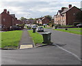
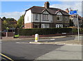
Wayland Road, Whitchurch, Shropshire
Looking south from near the corner of Station Road.
Image: © Jaggery
Taken: 22 Oct 2015
0.02 miles
2
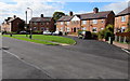
Wayland Road houses around a semicircle, Whitchurch, Shropshire
One of four similar semicircular arrangement of houses in Wayland Road.
Image: © Jaggery
Taken: 22 Oct 2015
0.02 miles
3
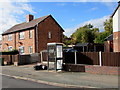
BT phonebox, Wayland Road, Whitchurch, Shropshire
At the northern end of Wayland Road, near the Station Road/Waylands junction.
Image: © Jaggery
Taken: 22 Oct 2015
0.05 miles
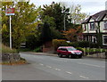
4
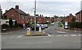
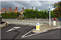
Junction of Wayland Road and the B5398, Whitchurch (Shropshire)
Looking along the northern end of Wayland Road from the edge of the B5398.
This junction is opposite the access road http://www.geograph.org.uk/photo/4903145 to Whitchurch (Shropshire) railway station.
Image: © Jaggery
Taken: 22 Oct 2015
0.05 miles
5
This way to Shrewsbury, Oswestry and Ellesmere from Whitchurch, Shropshire
The blue cycle route & footpath sign at the Station Road/Waylands junction points left along Wayland Road.
Image: © Jaggery
Taken: 22 Oct 2015
0.06 miles
6
Junction opposite the entrance road to Whitchurch (Shropshire) railway station
Viewed from Wayland Road looking towards the B5398.
The red postbox http://www.geograph.org.uk/photo/4722093 is on the corner of the station access road.
Image: © Jaggery
Taken: 22 Oct 2015
0.06 miles
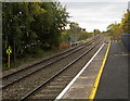
7
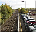
Railway south from Whitchurch (Shropshire) railway station
Viewed from the station footbridge. The next major station in this direction is Shrewsbury, 30km (about 19 miles) to the south. Some trains stop at the intermediate stations of Prees, Wem and Yorton, others do not.
This view shows that platform 2 (for northbound trains towards Crewe and Manchester Piccadilly) extends further south than platform 1, by about 40 metres.
In the middle distance, the tracks cross a road bridge. http://www.geograph.org.uk/photo/4748906
Image: © Jaggery
Taken: 22 Oct 2015
0.06 miles
8
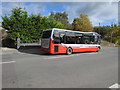
GHA Coaches single-decker in Station Road, Whitchurch, Shropshire
Heading away from the town centre on route 73 to Nantwich.
The red and white Whitchurch railway station name sign is on a pole on the right.
Image: © Jaggery
Taken: 22 Oct 2015
0.06 miles
9
Welsh Marches Line south from Whitchurch (Shropshire) railway station
Viewed from platform 2.
The next station ahead is Prees, though only local trains stop there. Wem station is beyond Prees.
The black X sign on the left is on the approach to the bridge carrying the tracks over the B5398.
Image: © Jaggery
Taken: 22 Oct 2015
0.06 miles
10
Whitchurch railway station name sign
Facing the B5398 on the corner of the station access road. http://www.geograph.org.uk/photo/4903145
This Whitchurch is in Shropshire.
Image: © Jaggery
Taken: 22 Oct 2015
0.06 miles