IMAGES TAKEN NEAR TO
Chester Road, WHITCHURCH, SY13 1NF
Introduction
This page details the photographs taken nearby to Chester Road, SY13 1NF by members of the Geograph project.
The Geograph project started in 2005 with the aim of publishing, organising and preserving representative images for every square kilometre of Great Britain, Ireland and the Isle of Man.

There are currently over 7.5m images from over14,400 individuals and you can help contribute to the project by visiting https://www.geograph.org.uk
Image Map
Images are licensed for reuse under creativecommons.org/licenses/by-sa/2.0
Notes
- Clicking on the map will re-center to the selected point.
- The higher the marker number, the further away the image location is from the centre of the postcode.
Image Listing (11 Images Found)
Images are licensed for reuse under creativecommons.org/licenses/by-sa/2.0
Image
Details
Distance
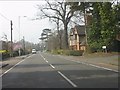
1
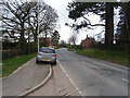
Chester Road, Whitchurch
Looking northwest on the B5395.
Image: © JThomas
Taken: 14 Mar 2019
0.01 miles
2
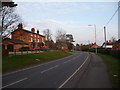
Part of Chester Road in Whitchurch
Some nice old properties along this stretch of the road.
Image: © Jeremy Bolwell
Taken: 2 Mar 2012
0.03 miles
5
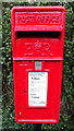
Elizabeth II postbox on Chester Road, Whitchurch
Postbox No. SY13 644.
See Image] for context.
Image: © JThomas
Taken: 14 Mar 2019
0.09 miles
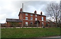
7
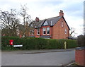
House on Chester Road, Whitchurch
Showing position of Postbox No. SY13 644.
See Image] for context.
Image: © JThomas
Taken: 14 Mar 2019
0.10 miles
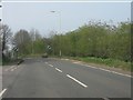
8
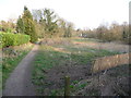
Footpath near Sherrymill Road
The footpath passes behind housing estates and developments shadowing a stream.
Image: © Jeremy Bolwell
Taken: 2 Mar 2012
0.19 miles
9
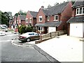
The Brambles
A rustic name for a not-very-rustic housing estate in Whitchurch.
Image: © Oliver Dixon
Taken: 26 Jun 2023
0.20 miles
10
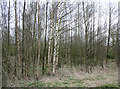
Birches in Whitchurch Waterway Country Park
A narrow corridor from the centre of Whitchurch westwards that once formed the route of the Whitchurch Arm of the Llangollen Branch of the Shropshire Union has been designed the Whitchurch Waterway Country Park and protected from development. The vegetation is a mix of young deciduous woodland and rough grass, with several paths including the start of the Sandstone Trail. Unfortunately, the popularity of the area with walkers, cyclists and dogs has led to considerable amounts of litter and dog faeces
Image: © Espresso Addict
Taken: 31 Mar 2009
0.21 miles