IMAGES TAKEN NEAR TO
Poplar Close, Wrexham Road, WHITCHURCH, SY13 1JX
Introduction
This page details the photographs taken nearby to Poplar Close, Wrexham Road, SY13 1JX by members of the Geograph project.
The Geograph project started in 2005 with the aim of publishing, organising and preserving representative images for every square kilometre of Great Britain, Ireland and the Isle of Man.

There are currently over 7.5m images from over14,400 individuals and you can help contribute to the project by visiting https://www.geograph.org.uk
Image Map (Loading...)


Getting Data...Please wait
Leaflet Map data © OpenStreetMap
Images are licensed for reuse under creativecommons.org/licenses/by-sa/2.0
Notes
- Clicking on the map will re-center to the selected point.
- The higher the marker number, the further away the image location is from the centre of the postcode.
Image Listing (33 Images Found)
Images are licensed for reuse under creativecommons.org/licenses/by-sa/2.0
Image
Details
Distance
1
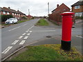
Thompson Drive, Whitchurch
Showing position of Postbox No. SY13 755.
See Image] for postbox.
Image: © JThomas
Taken: 14 Mar 2019
0.04 miles
2
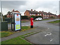
Elizabeth II postbox and telephone box on Wrexham Road, Whitchurch
Showing position of Postbox No. SY13 755.
See Image] for postbox.
Image: © JThomas
Taken: 14 Mar 2019
0.04 miles
3
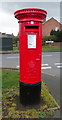
Elizabeth II postbox on Wrexham Road, Whitchurch
Image: © JThomas
Taken: 14 Mar 2019
0.04 miles
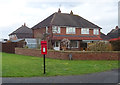
4
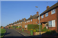
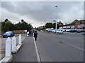
Wrexham Road, Whitchurch
These houses are located on a short dead-end service road parallel to one of the main routes out of Whitchurch.
Image: © Stephen McKay
Taken: 8 Oct 2008
0.08 miles
5
Wrexham Road, Whitchurch
Looking west on the B5395.
Image: © JThomas
Taken: 14 Mar 2019
0.16 miles
6

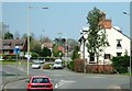
Chemistry
This unusual name is derived from a local farm and now applies not only to a road but also the western suburb of Whitchurch.
Image: © Stephen McKay
Taken: 7 Oct 2008
0.17 miles
7
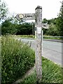
Signpost for many paths at Greenfields Way
This signpost is adorned with markers for a number of different paths including the long-distance Sandstone Trail, the Shropshire Way and Whitchurch Town Trail.
Image: © Oliver Dixon
Taken: 26 Jun 2023
0.17 miles
8
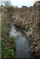
Bulrushes by Stag Brook, Whitchurch
A narrow corridor from the centre of Whitchurch westwards that once formed the route of the Whitchurch Arm of the Llangollen Branch of the Shropshire Union has been designed the Whitchurch Waterway Country Park and protected from development. Stag Brook winds its way through the corridor; at this point, immediately to the west of the bridge carrying Greenfields Rise (houses on the right), the brook is lined with bulrushes and clumps of celandine. The area forms a habitat for water voles. See also Image
Image: © Espresso Addict
Taken: 31 Mar 2009
0.18 miles
10
Elizabeth II postbox on Chemistry, Whitchurch
Image: © JThomas
Taken: 14 Mar 2019
0.18 miles