IMAGES TAKEN NEAR TO
Queensway, WHITCHURCH, SY13 1EY
Introduction
This page details the photographs taken nearby to Queensway, SY13 1EY by members of the Geograph project.
The Geograph project started in 2005 with the aim of publishing, organising and preserving representative images for every square kilometre of Great Britain, Ireland and the Isle of Man.

There are currently over 7.5m images from over14,400 individuals and you can help contribute to the project by visiting https://www.geograph.org.uk
Image Map (Loading...)


Getting Data...Please wait
Leaflet Map data © OpenStreetMap
Images are licensed for reuse under creativecommons.org/licenses/by-sa/2.0
Notes
- Clicking on the map will re-center to the selected point.
- The higher the marker number, the further away the image location is from the centre of the postcode.
Image Listing (100 Images Found)
Images are licensed for reuse under creativecommons.org/licenses/by-sa/2.0
Image
Details
Distance
1
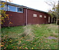
Former Whitchurch Ambulance Station, Shropshire
The Sedgeford side of the single-storey building on the corner of Queensway.
Viewed in October 2015 when a nearby For Sale board states
Development Opportunity (Subject to Planning Permission).
Planning Submitted for 6 Dwellings.
0.14 Hectares (0.36 acres).
Image: © Jaggery
Taken: 22 Oct 2015
0.01 miles
2
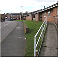
Ramp to Queensway bungalows, Whitchurch, Shropshire
From the corner of the B5395 Sedgeford.
Image: © Jaggery
Taken: 22 Oct 2015
0.02 miles
3
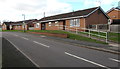
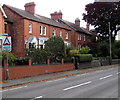
Queensway bungalows, Whitchurch, Shropshire
Viewed from the corner of the B5395 Sedgeford.
Originally, bungalow was used in English for a lightly-built house, with a veranda and one storey.
In current UK usage it is a convenient word for any one-storey dwelling.
Image: © Jaggery
Taken: 22 Oct 2015
0.02 miles
4
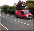
Royal Mail van, Sedgeford, Whitchurch, Shropshire
Viewed across the B5395 Sedgeford.
Image: © Jaggery
Taken: 22 Oct 2015
0.03 miles
5
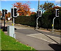
Pelican crossing, Sedgeford, Whitchurch, Shropshire
Across the B5395 Sedgeford viewed from the corner of Queensway.
Chambers Dictionary states that "pelican" is adapted from "pedestrian light controlled crossing".
Image: © Jaggery
Taken: 22 Oct 2015
0.03 miles
6
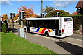
Bryn Melyn bus in Whitchurch, Shropshire
The bus on route 205 Whitchurch Town Circular is on the B5395 Sedgeford towards the town centre.
Image: © Jaggery
Taken: 22 Oct 2015
0.03 miles
7
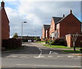
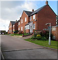
South side of Dodington Close, Whitchurch, Shropshire
Cul-de-sac on the west side of the B5395 Sedgeford.
Image: © Jaggery
Taken: 22 Oct 2015
0.04 miles
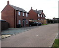
8
Dodington Close, Whitchurch (Shropshire)
Cul-de-sac on the west side of the B5395 Sedgeford.
Image: © Jaggery
Taken: 22 Oct 2015
0.04 miles
9
Warning sign - humps for half-a-mile ahead, Sedgeford, Whitchurch, Shropshire
The red-edged triangular sign is on the east side of the B5395 Sedgeford.
Image: © Jaggery
Taken: 22 Oct 2015
0.04 miles
10
North side of Dodington Close, Whitchurch, Shropshire
Cul-de-sac on the west side of the B5395 Sedgeford.
Image: © Jaggery
Taken: 22 Oct 2015
0.05 miles