IMAGES TAKEN NEAR TO
Dodington, WHITCHURCH, SY13 1ER
Introduction
This page details the photographs taken nearby to Dodington, SY13 1ER by members of the Geograph project.
The Geograph project started in 2005 with the aim of publishing, organising and preserving representative images for every square kilometre of Great Britain, Ireland and the Isle of Man.

There are currently over 7.5m images from over14,400 individuals and you can help contribute to the project by visiting https://www.geograph.org.uk
Image Map
Images are licensed for reuse under creativecommons.org/licenses/by-sa/2.0
Notes
- Clicking on the map will re-center to the selected point.
- The higher the marker number, the further away the image location is from the centre of the postcode.
Image Listing (131 Images Found)
Images are licensed for reuse under creativecommons.org/licenses/by-sa/2.0
Image
Details
Distance
1
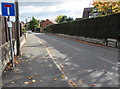
No Through Road sign, Edgeley Road, Whitchurch (Shropshire)
The sign faces the B5395 Sedgeford junction. Old maps show that Edgeley Road used to be a through road.
Now it is severed by the A525, about 800 metres ahead. Near the A525, metal barriers across Edgeley Road block the passage of motor vehicles, but not walkers and cyclists.
Image: © Jaggery
Taken: 22 Oct 2015
0.01 miles
2
Late Victorian drinking fountain on a Whitchurch corner
Dated 1899, http://www.geograph.org.uk/photo/4800740 the fountain is on the corner of Edgeley Road and the B5395 Sedgeford.
Image: © Jaggery
Taken: 22 Oct 2015
0.02 miles
3
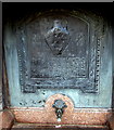
Depiction of a cinerary urn, Whitchurch
Part of this http://www.geograph.org.uk/photo/4800739 late Victorian drinking fountain. The inscription is
NOVEMBER 1899
A CINERARY URN OF WHICH THIS IS A REPRESENTATION WAS
DISCOVERED IN DIGGING THE FOUNDATION OF THIS WALL.
A cinerary urn was used to hold the ashes of the dead after cremation.
Image: © Jaggery
Taken: 22 Oct 2015
0.02 miles
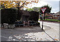
4
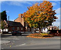
Mini-roundabout in the south of Whitchurch, Shropshire
At the junction of three roads - Newport Road, Dodington and Sedgeford.
Sedgeford on the right is the road for Wolverhampton, Shrewsbury and Wem.
Image: © Jaggery
Taken: 22 Oct 2015
0.02 miles
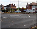
5
Junction of two B roads, Whitchurch (Shropshire)
The B5476 Dodington is on the left. The B5395 Newport Road is on the right.
Image: © Jaggery
Taken: 22 Oct 2015
0.03 miles
6
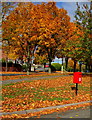
Gold and red, Newport Road, Whitchurch (Shropshire)
Autumn colours and a red postbox on October 22nd 2015.
Image: © Jaggery
Taken: 22 Oct 2015
0.03 miles
7
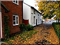
Carpet of autumn leaves, Dodington, Whitchurch, Shropshire
Viewed on October 22nd 2015.
Image: © Jaggery
Taken: 22 Oct 2015
0.03 miles
8
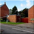
Dodington Lodge electricity substation, Whitchurch, Shropshire
Inside a brick structure on the corner of Dodington Close and the B5395 Sedgeford.
Image: © Jaggery
Taken: 22 Oct 2015
0.03 miles
9
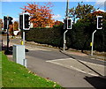
Pelican crossing, Sedgeford, Whitchurch, Shropshire
Across the B5395 Sedgeford viewed from the corner of Queensway.
Chambers Dictionary states that "pelican" is adapted from "pedestrian light controlled crossing".
Image: © Jaggery
Taken: 22 Oct 2015
0.04 miles
10
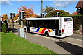
Bryn Melyn bus in Whitchurch, Shropshire
The bus on route 205 Whitchurch Town Circular is on the B5395 Sedgeford towards the town centre.
Image: © Jaggery
Taken: 22 Oct 2015
0.04 miles