IMAGES TAKEN NEAR TO
Didcot Close, SHREWSBURY, SY1 2UH
Introduction
This page details the photographs taken nearby to Didcot Close, SY1 2UH by members of the Geograph project.
The Geograph project started in 2005 with the aim of publishing, organising and preserving representative images for every square kilometre of Great Britain, Ireland and the Isle of Man.

There are currently over 7.5m images from over14,400 individuals and you can help contribute to the project by visiting https://www.geograph.org.uk
Image Map
Images are licensed for reuse under creativecommons.org/licenses/by-sa/2.0
Notes
- Clicking on the map will re-center to the selected point.
- The higher the marker number, the further away the image location is from the centre of the postcode.
Image Listing (42 Images Found)
Images are licensed for reuse under creativecommons.org/licenses/by-sa/2.0
Image
Details
Distance
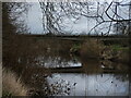
2
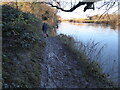
Riverside path in Shrewsbury
Clarty! (Meaning muddy and/or sticky). Recent flood waters receding has resulted in a thin layer of deposits being laid that turns the surface into a slippery rink on which all boots slide, skid and slip.
Image: © Jeremy Bolwell
Taken: 2 Jan 2021
0.07 miles
3
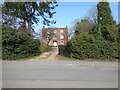
Old Georgian farm house, now flats
Nice place!
Image: © Jeremy Bolwell
Taken: 7 Mar 2021
0.09 miles
4
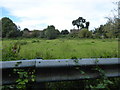
Narrow fields between housing and the River Severn in Shrewsbury at Ditherington
A buffer zone due to flood risk I assume.
Image: © Jeremy Bolwell
Taken: 6 Sep 2020
0.12 miles
5
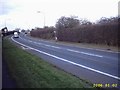
A5112 Telford Way
The Shrewsbury Canal used to run across here.
Image: © Mr M Evison
Taken: 2 Jan 2006
0.14 miles
6
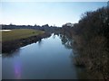
River Severn from Telford Way road bridge
Image: © Mr M Evison
Taken: 7 Mar 2010
0.15 miles
7
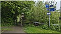
Footpath entrance and cycle path signage
The start of a section of the riverside footpath - but cycles are prohibited here, instead continuing on National Cycle Route 81 along quiet roads.
Image: © TCExplorer
Taken: 6 May 2023
0.15 miles
8

Meadows beside the Severn in Shrewsbury
This is another cold pocket of land, low lying, adjacent to the large body of cold water and poorly drained, retaining seasonal floodwaters and offering a family here a chance to play with ice, the dog included.
Image: © Jeremy Bolwell
Taken: 2 Jan 2021
0.16 miles
9
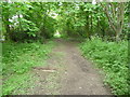
Part of the Severn Way near Ditherington, Shrewsbury
The path heads into the town from here.
Image: © Jeremy Bolwell
Taken: 4 May 2012
0.16 miles
10
Telford Way Bridge, Shrewsbury
The bridge spans the River Severn and carries the busy A5112. The Shropshire Way nearly falls into the river at this point.
Image: © Andrew Shannon
Taken: 22 Feb 2023
0.17 miles