IMAGES TAKEN NEAR TO
Felton Close, SHREWSBURY, SY1 2TX
Introduction
This page details the photographs taken nearby to Felton Close, SY1 2TX by members of the Geograph project.
The Geograph project started in 2005 with the aim of publishing, organising and preserving representative images for every square kilometre of Great Britain, Ireland and the Isle of Man.

There are currently over 7.5m images from over14,400 individuals and you can help contribute to the project by visiting https://www.geograph.org.uk
Image Map
Images are licensed for reuse under creativecommons.org/licenses/by-sa/2.0
Notes
- Clicking on the map will re-center to the selected point.
- The higher the marker number, the further away the image location is from the centre of the postcode.
Image Listing (82 Images Found)
Images are licensed for reuse under creativecommons.org/licenses/by-sa/2.0
Image
Details
Distance
2
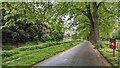
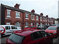
Sydney Avenue
A proper avenue - lovely trees lining this quiet road. The river is just to the left of the grass verge.
Image: © TCExplorer
Taken: 6 May 2023
0.10 miles
3
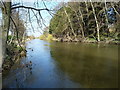
River left beside France Island
The Severn splits either side of France Island; this is the left channel.
Image: © Richard Law
Taken: 5 Apr 2015
0.11 miles
4
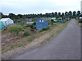
Allottment gardens in Castlefields, Shrewsbury
Active allotment plots well tended here.
Image: © Jeremy Bolwell
Taken: 10 Jun 2020
0.11 miles
5
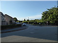
Junction of Woodhall Close, Castlefields, Shrewsbury
A tractor is parked over there.
Image: © Jeremy Bolwell
Taken: 14 Jun 2020
0.13 miles
6
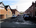
John Street, Castlefields, Shrewsbury
Viewed from Newpark Road looking along John Street towards Castlefields Allotments.
John Street Church http://www.geograph.org.uk/photo/5159143 is on the left.
Image: © Jaggery
Taken: 17 Oct 2016
0.13 miles
7
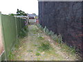
Cobbled alleyway on John Street, Castlefields, Shrewsbury
Providing rear access to the terrace on the right, named Pretoria Terrace, and apparently built by LMS railway for their Shrewsbury based train drivers in the 1890s.
Image: © Jeremy Bolwell
Taken: 10 Jun 2020
0.14 miles
8
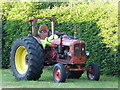
Tractor on Woodhall Close
Maybe he has parked up to visit someone?
Image: © Jeremy Bolwell
Taken: 14 Jun 2020
0.14 miles
9
1-8 Pretoria Terrace, John Street, Castlefields, Shrewsbury
Apparently built by LMS railway for their Shrewsbury based train drivers in the late Victorian era. The houses have stone flagged back yards rather than gardens, and also an alley, fully cobbled, running around them to give rear access and vehicular access, quite rare in this suburb.
Image: © Jeremy Bolwell
Taken: 10 Jun 2020
0.14 miles
10
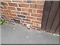
Ordnance Survey Cut Mark
This OS cut mark can be found on No157 New Park Road . It marks a point 52.791m above mean sea level.
Image: © Adrian Dust
Taken: 3 Jul 2023
0.15 miles