1
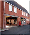
Jet King Hand Car Wash, Shrewsbury
On the north side of Newpark Road.
Image: © Jaggery
Taken: 31 May 2014
0.03 miles
2
You can call on me anytime, Water Street, Shrewsbury
The title text is on a Wall's ice cream advert on a Water Street silver phonebox.
Water Street Flats are in the background.
Image: © Jaggery
Taken: 31 May 2014
0.04 miles
3
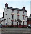
The Canal Tavern Public House, New Park Road, Shrewsbury
An early 19C building of whitewashed brick with a Welsh slate roof. There is an extensive range of outbuildings at the right end, looking somewhat agricultural. The pub was built at the side of the former Shrewsbury Canal.
Image: © Humphrey Bolton
Taken: 15 Sep 2001
0.04 miles
4
Castle Fields, Shrewsbury
This is a 19C suburb with long terraces of brick houses with a fascinating variety of detailing. Note the chequered brickwork of the second house from the left, and its segmentally arched windows. All Saints Church was built in 1876, in brick like the houses. Photo taken in the evening, hence the pale sunlight.
Image: © Humphrey Bolton
Taken: 15 Sep 2001
0.05 miles
5
North Street trees, Shrewsbury
At the western end of North Street, near the Newpark Road junction.
Image: © Jaggery
Taken: 31 May 2014
0.05 miles
6
The old Canal Tavern, Castlefields, Shrewsbury
Closed and soon to be developed into residential flats I believe.
Image: © Jeremy Bolwell
Taken: 3 Jan 2021
0.05 miles
7
Siren hair and beauty salon, Castlefields, Shrewsbury
Alongside New Park Road.
Image: © Jaggery
Taken: 17 Oct 2016
0.05 miles
8
Queen Elizabeth II pillarbox, Castlefields, Shrewsbury
Located here. http://www.geograph.org.uk/photo/5159189
Image: © Jaggery
Taken: 17 Oct 2016
0.05 miles
9
Former pub, Newpark Road, Shrewsbury
Once the Canal Tavern, an early C19th pub (shown on an 1838 map) with jolly red lintels. Grade II listed.
Its generally dilapidated state was a clue to it having bitten the dust (even its canal seems to have gone). What future for a building like this?
Image: © Stephen Richards
Taken: 16 May 2014
0.05 miles
10
The rear aspect of the Canal Tavern, Castlefields, Shrewsbury
Wines and Spirits and Wem Ales states the old painted banner on the rear aspect of the now closed tavern.
The old Shrewsbury Canal used to pass in this little footpath culvert I think.
Image: © Jeremy Bolwell
Taken: 3 Jan 2021
0.05 miles


