IMAGES TAKEN NEAR TO
Cedars Drive, SHREWSBURY, SY1 2RD
Introduction
This page details the photographs taken nearby to Cedars Drive, SY1 2RD by members of the Geograph project.
The Geograph project started in 2005 with the aim of publishing, organising and preserving representative images for every square kilometre of Great Britain, Ireland and the Isle of Man.

There are currently over 7.5m images from over14,400 individuals and you can help contribute to the project by visiting https://www.geograph.org.uk
Image Map
Images are licensed for reuse under creativecommons.org/licenses/by-sa/2.0
Notes
- Clicking on the map will re-center to the selected point.
- The higher the marker number, the further away the image location is from the centre of the postcode.
Image Listing (17 Images Found)
Images are licensed for reuse under creativecommons.org/licenses/by-sa/2.0
Image
Details
Distance
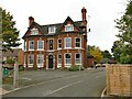
2
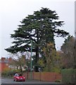
Cedar beside Ellesmere Road, Shrewsbury
Image: © David Smith
Taken: 28 Nov 2014
0.13 miles
3
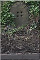
Old Milestone by the A528, Ellesmere Road, north of Shrewsbury
Stone post (plate lost) by the A528, in parish of SHREWSBURY (SHREWSBURY AND ATCHAM District), opposite Normanton Retirement Home, Ellesmere Road, by the road. Erected by the Ellesmere District of Shrewsbury & Wrexham, & Harmer Hill Branch turnpike trust in the 19th century.
Inscription once read:-
(Shrewsbury 1)
Listed Shropshire HER: 21079 https://www.heritagegateway.org.uk/Gateway/Results_Single.aspx?uid=MSA23648&resourceID=1015
Milestone Society National ID: SA_WMSB09.
Image: © A Reade
Taken: 19 Aug 2008
0.14 miles
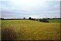
4
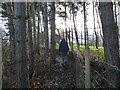
Path beside the railway line past Coton Grange
A lovely spot on a winter afternoon.
Image: © Jeremy Bolwell
Taken: 3 Jan 2021
0.15 miles
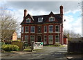
7
The Moveage, Ellesmere Road
Old maps do show a large of that name on a nearby site. Grace's Guide online shows it was occupied in 1917 by G. Woodvine, Engineer. But it's not the present structure. The grounds have been used to develop social housing.
Image: © Stephen Craven
Taken: 16 Oct 2022
0.17 miles
8
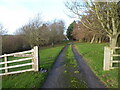
The entrance drive to Coton Grange
Impressive.
Image: © Jeremy Bolwell
Taken: 29 Dec 2021
0.17 miles
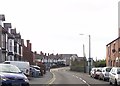
9
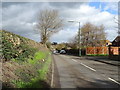
Ellesmere Road (A528), Shrewsbury
Looking north.
Image: © JThomas
Taken: 14 Mar 2019
0.17 miles
10
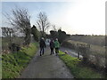
A winter walk near Coton Hill, Shrewsbury
Great to get out and enjoy some fresh air.
Image: © Jeremy Bolwell
Taken: 29 Dec 2021
0.17 miles