IMAGES TAKEN NEAR TO
Falstaff Street, SHREWSBURY, SY1 2QW
Introduction
This page details the photographs taken nearby to Falstaff Street, SY1 2QW by members of the Geograph project.
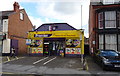
The Geograph project started in 2005 with the aim of publishing, organising and preserving representative images for every square kilometre of Great Britain, Ireland and the Isle of Man.

There are currently over 7.5m images from over14,400 individuals and you can help contribute to the project by visiting https://www.geograph.org.uk
Image Map
Images are licensed for reuse under creativecommons.org/licenses/by-sa/2.0
Notes
- Clicking on the map will re-center to the selected point.
- The higher the marker number, the further away the image location is from the centre of the postcode.
Image Listing (110 Images Found)
Images are licensed for reuse under creativecommons.org/licenses/by-sa/2.0
Image
Details
Distance
1
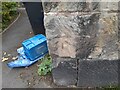
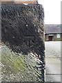
Ordnance Survey Cut Mark
This OS cut mark can be found on the graveyard wall SE side of Crewe Street. It marks a point 60.484m above mean sea level.
Image: © Adrian Dust
Taken: 3 Jul 2023
0.15 miles
2
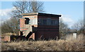
Shrewsbury Crewe Bank Signal Box
Shrewsbury Crewe Bank Signal Box, switched out, all main line signals cleared. An ARP design built by the GWR during World War Two. From what I gather this box is only manned when certain local movements are required. I also understand that Network Rail have permission to abolish and demolish so it certainly seems to be living on borrowed time.
Image: © Tim Marshall
Taken: 16 Feb 2010
0.16 miles
3
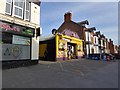
Mini supermarket and post office, Greenfields, Shrewsbury
The post office was formerly further south, at Wood Street, and the postbox is still outside the old site
Image: © David Smith
Taken: 23 Apr 2015
0.16 miles
4
SPAR store, Ellesmere Road
Formerly part of the Premier chain Image
Image: © Stephen Craven
Taken: 16 Oct 2022
0.16 miles
5
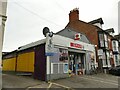
Post Office and stores on Ellesmere Road, Shrewsbury
Image: © JThomas
Taken: 14 Mar 2019
0.16 miles
6
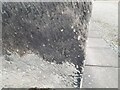
OS benchmark - Castlefields, tower of St Michael's church
An OS cutmark at the base of the tower of the former church (now a Masonic Hall) on Crewe Street. It was originally levelled, probably in 1967 at 60.92m above Ordnance Datum Newlyn.
Image: © Richard Law
Taken: 31 May 2018
0.16 miles
7
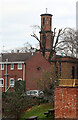
St Michael's Church, Shrewsbury
Now a Masonic Hall.
Image: © Chris Allen
Taken: 3 Dec 2022
0.17 miles
8
Ordnance Survey Cut Mark
This OS cut mark can be found on the west angle of St Michael's Church. It marks a point 60.920m above mean sea level.
Image: © Adrian Dust
Taken: 3 Jul 2023
0.17 miles
9
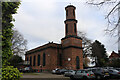
Former Church of St Michael, Shrewsbury
Now a Masonic hall. Built 1829 and Listed Grade II.
Image: © Chris Allen
Taken: 3 Dec 2022
0.17 miles
10

Lane behind Ditherington Mill site, 1990
More modern buildings on the flax mill site, which was converted to maltings in 1897, closing in 1987. The original buildings are mostly grade I listed. This lane seems quite old, it went nowhere except water meadows, but now is part of a cycle and footpath system.
Image: © Robin Webster
Taken: 27 Sep 1990
0.18 miles