IMAGES TAKEN NEAR TO
New Park Street, SHREWSBURY, SY1 2LA
Introduction
This page details the photographs taken nearby to New Park Street, SY1 2LA by members of the Geograph project.
The Geograph project started in 2005 with the aim of publishing, organising and preserving representative images for every square kilometre of Great Britain, Ireland and the Isle of Man.

There are currently over 7.5m images from over14,400 individuals and you can help contribute to the project by visiting https://www.geograph.org.uk
Image Map
Images are licensed for reuse under creativecommons.org/licenses/by-sa/2.0
Notes
- Clicking on the map will re-center to the selected point.
- The higher the marker number, the further away the image location is from the centre of the postcode.
Image Listing (250 Images Found)
Images are licensed for reuse under creativecommons.org/licenses/by-sa/2.0
Image
Details
Distance
1
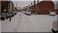
Snowy scene on New Park Street
The first of two really snowy periods in the winter of 2017-2018.
Image: © Andrew Abbott
Taken: 10 Dec 2017
0.01 miles
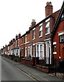
2
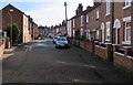
New Park Street, Castlefields, Shrewsbury
Looking east towards Queen Street.
Image: © Jaggery
Taken: 17 Oct 2016
0.02 miles
3
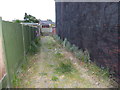
Cobbled alleyway on John Street, Castlefields, Shrewsbury
Providing rear access to the terrace on the right, named Pretoria Terrace, and apparently built by LMS railway for their Shrewsbury based train drivers in the 1890s.
Image: © Jeremy Bolwell
Taken: 10 Jun 2020
0.03 miles
4
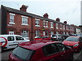
1-8 Pretoria Terrace, John Street, Castlefields, Shrewsbury
Apparently built by LMS railway for their Shrewsbury based train drivers in the late Victorian era. The houses have stone flagged back yards rather than gardens, and also an alley, fully cobbled, running around them to give rear access and vehicular access, quite rare in this suburb.
Image: © Jeremy Bolwell
Taken: 10 Jun 2020
0.04 miles
5
Queen Street houses, Shrewsbury
Houses on the east side of Queen Street. All Saints Hall http://www.geograph.org.uk/photo/4643862 is on the right.
Image: © Jaggery
Taken: 31 May 2014
0.04 miles
6
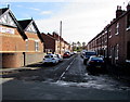
John Street, Castlefields, Shrewsbury
Viewed from Newpark Road looking along John Street towards Castlefields Allotments.
John Street Church http://www.geograph.org.uk/photo/5159143 is on the left.
Image: © Jaggery
Taken: 17 Oct 2016
0.05 miles
7
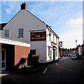
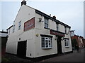
The Telegraph, Castlefields, Shrewsbury
Also known as the Telegraph Vaults, The Telegraph pub is at 16 New Park Street,
next door to Castlefields Community Hall. http://www.geograph.org.uk/photo/5159149 See http://www.geograph.org.uk/photo/5159171 for the pub's name sign depicting Samuel Morse.
Image: © Jaggery
Taken: 17 Oct 2016
0.05 miles
8
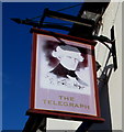
The Telegraph pub name sign, Castlefields, Shrewsbury
Hanging from a wall bracket here, http://www.geograph.org.uk/photo/5159159 the sign depicts the American inventor Samuel Morse, who helped to develop the telegraph & Morse Code systems. The What Pub website states that he has no known Shropshire links. The connection appears to be that the pub opened at about the time he died in 1872.
Image: © Jaggery
Taken: 17 Oct 2016
0.05 miles
9
The Telegraph Vaults public house in Castefields, Shrewsbury
One of two remaining pubs serving this Victorian suburb.
It boasts having the longest bar in Shropshire. Or did, until internal reorganisation several years ago, which necessitated shortening the length of the bar.
Popular with tennis players (there being two tennis courts a short walk away), locals of course and community groups and teams.
The signage is faded and weathered
Image: © Jeremy Bolwell
Taken: 16 Nov 2021
0.05 miles
10
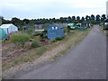
Allottment gardens in Castlefields, Shrewsbury
Active allotment plots well tended here.
Image: © Jeremy Bolwell
Taken: 10 Jun 2020
0.05 miles