IMAGES TAKEN NEAR TO
North Street, SHREWSBURY, SY1 2JL
Introduction
This page details the photographs taken nearby to North Street, SY1 2JL by members of the Geograph project.
The Geograph project started in 2005 with the aim of publishing, organising and preserving representative images for every square kilometre of Great Britain, Ireland and the Isle of Man.

There are currently over 7.5m images from over14,400 individuals and you can help contribute to the project by visiting https://www.geograph.org.uk
Image Map
Images are licensed for reuse under creativecommons.org/licenses/by-sa/2.0
Notes
- Clicking on the map will re-center to the selected point.
- The higher the marker number, the further away the image location is from the centre of the postcode.
Image Listing (246 Images Found)
Images are licensed for reuse under creativecommons.org/licenses/by-sa/2.0
Image
Details
Distance
1
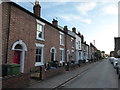
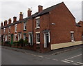
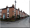
Part of North Street, Castlefields, Shrewsbury
A late Victorian terraced street in this central suburb.
Image: © Jeremy Bolwell
Taken: 6 Jun 2020
0.00 miles
2
East along North Street, Shrewsbury
Houses on the north side of North Street, east of All Saints Parish Church. http://www.geograph.org.uk/photo/4643767
Image: © Jaggery
Taken: 31 May 2014
0.02 miles
3
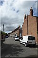
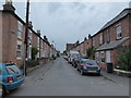
Burton Street
Looking along Burton Street from the junction with Sydney Avenue.
Image: © DS Pugh
Taken: 29 Jul 2018
0.03 miles
4
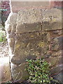
OS benchmark - Shrewsbury Castlefields, All Saints Church
An OS cutmark on the base of the side wall of the church in Image; originally levelled in 1951 at 52.877m above Ordnance Datum Newlyn.
Image: © Richard Law
Taken: 5 Apr 2015
0.03 miles
5
Corner of North Street and West Street, Shrewsbury
Opposite All Saints Parish Church. http://www.geograph.org.uk/photo/4643767
Image: © Jaggery
Taken: 31 May 2014
0.03 miles
6
North Street, Castlefields, Shrewsbury looking west
North Street runs east-west.
Image: © Jeremy Bolwell
Taken: 10 Jun 2020
0.03 miles
7
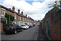
Along Burton Street
Looking along Burton Street in Shrewsbury.
Image: © DS Pugh
Taken: 29 Jul 2018
0.03 miles
8
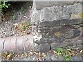
Ordnance Survey Cut Mark
This OS cut mark can be found on the SE angle of All Saints Church. It marks a point 52.877m above mean sea level.
Image: © Adrian Dust
Taken: 3 Jul 2023
0.04 miles
9
Corner of Queen Street and North Street, Shrewsbury
North Street viewed from Queen Street.
Image: © Jaggery
Taken: 31 May 2014
0.04 miles
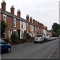
10
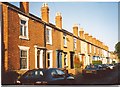
A row of houses in Castle Fields, Shrewsbury
The varying styles of brickwork and decoration make this suburb attractive and interesting.
Image: © Humphrey Bolton
Taken: 15 Sep 2001
0.04 miles