IMAGES TAKEN NEAR TO
Victoria Street, SHREWSBURY, SY1 2HS
Introduction
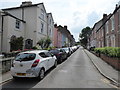
This page details the photographs taken nearby to Victoria Street, SY1 2HS by members of the Geograph project.
The Geograph project started in 2005 with the aim of publishing, organising and preserving representative images for every square kilometre of Great Britain, Ireland and the Isle of Man.

There are currently over 7.5m images from over14,400 individuals and you can help contribute to the project by visiting https://www.geograph.org.uk
Image Map
Images are licensed for reuse under creativecommons.org/licenses/by-sa/2.0
Notes
- Clicking on the map will re-center to the selected point.
- The higher the marker number, the further away the image location is from the centre of the postcode.
Image Listing (810 Images Found)
Images are licensed for reuse under creativecommons.org/licenses/by-sa/2.0
Image
Details
Distance
1
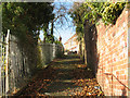
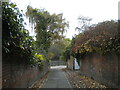
The Dana - going up from the river
The Dana - which is also the name of the nearby prison Image - is a historic footpath running from the river, past the prison and over the railway station on a footbridge, ending up by the castle.
Image: © Stephen Craven
Taken: 20 Nov 2008
0.00 miles
2
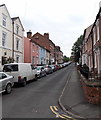
Victoria Street, Shrewsbury
From the corner of Severn Street.
Image: © Jaggery
Taken: 31 May 2014
0.01 miles
3
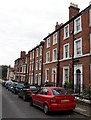
Victoria Street cars and houses, Shrewsbury
On-street parking in Victoria Street on the north bank of the River Severn.
Image: © Jaggery
Taken: 31 May 2014
0.01 miles
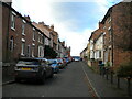
4
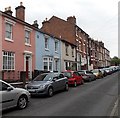
From two to three storeys, Victoria Street, Shrewsbury
Victoria Street is on the north bank of the River Severn.
Image: © Jaggery
Taken: 31 May 2014
0.02 miles
5
Victoria Street, Castlefields, Shrewsbury
A stylish street with taller houses.
Image: © Jeremy Bolwell
Taken: 17 Jun 2020
0.03 miles
6
Albert Street, Castlefields
Off Victoria Street.
Image: © Richard Vince
Taken: 20 Nov 2021
0.03 miles
7
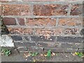
Ordnance Survey Cut Mark
This OS cut mark can be found on the wall of No26 Victoria Street. It marks a point 57.879m above mean sea level.
Image: © Adrian Dust
Taken: 3 Jul 2023
0.03 miles
8
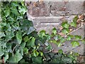
Ordnance Survey Cut Mark
This OS cut mark can be found on the wall at the rear of No12 Victoria Street. It marks a point 49.625m above mean sea level.
Image: © Adrian Dust
Taken: 3 Jul 2023
0.03 miles
9
Severn Street, Castlefields (2)
Leading from Victoria Street to, appropriately, the River Severn.
Image: © Richard Vince
Taken: 20 Nov 2021
0.03 miles
10
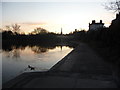
Part of the River Severn in Shrewsbury
The mighty river as the sun sets over the old town.
Image: © Jeremy Bolwell
Taken: 28 Jan 2012
0.03 miles