IMAGES TAKEN NEAR TO
The Dana, SHREWSBURY, SY1 2HP
Introduction
This page details the photographs taken nearby to The Dana, SY1 2HP by members of the Geograph project.
The Geograph project started in 2005 with the aim of publishing, organising and preserving representative images for every square kilometre of Great Britain, Ireland and the Isle of Man.

There are currently over 7.5m images from over14,400 individuals and you can help contribute to the project by visiting https://www.geograph.org.uk
Image Map
Images are licensed for reuse under creativecommons.org/licenses/by-sa/2.0
Notes
- Clicking on the map will re-center to the selected point.
- The higher the marker number, the further away the image location is from the centre of the postcode.
Image Listing (958 Images Found)
Images are licensed for reuse under creativecommons.org/licenses/by-sa/2.0
Image
Details
Distance
2
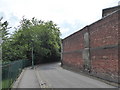
On the Dana beside Shrewsbury Prison walls
One of those strange little street scenes.
Image: © Jeremy Bolwell
Taken: 17 Jun 2020
0.02 miles
3
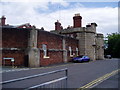
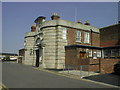
Shrewsbury Prison
There has been a prison on the site since 1793, but the present prison was built in 1877.
Image: © Eirian Evans
Taken: 1 Aug 2008
0.03 miles
4
HM Prison Shrewsbury from the river side
Image: © Roy Haworth
Taken: 16 Aug 2003
0.03 miles
5
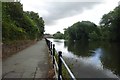
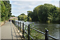
River below the railway
Looking downstream along the River Severn from the bottom of a path leading from The Dana.
Image: © DS Pugh
Taken: 29 Jul 2018
0.03 miles
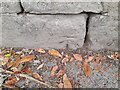
6
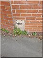
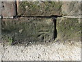
OS benchmark - Shrewsbury, riverside walk below the former prison
An OS cutmark on the retaining wall of the bank beside the riverside walk; originally levelled at 48.984m above Ordnance Datum Newlyn.
Image: © Richard Law
Taken: 5 Apr 2015
0.03 miles
7

Shrewsbury Prison
The prison closed in 2013 and is now a visitor attraction - hence the rather wide open entrance!
Image: © David Martin
Taken: 14 Sep 2022
0.04 miles
8
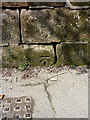
Bench mark on the riverside wall
This bench mark is on the wall next to the riverside path. The muddy state of the path and wall shows that the river level has only recently subsided after a period of heavy rain. See also Image
Image: © John S Turner
Taken: 29 Sep 2012
0.04 miles
9
Ordnance Survey Cut Mark
This OS cut mark can be found on the wall NW side of riverside path . It marks a point 48.984m above mean sea level.
Image: © Adrian Dust
Taken: 3 Jul 2023
0.04 miles