1
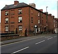
Row of 3-storey houses, St Michael's Street, Shrewsbury
Arranged in groups of two houses, with the front doors side by side, between the windows of each house.
Image: © Jaggery
Taken: 16 Nov 2015
0.02 miles
2
The Malting
This is the first iron framed constructed building in the world and now under ownership of The English Heritage
Image: © Mr M Evison
Taken: 2 Jan 2006
0.02 miles
3
Ann's Hill, Shrewsbury
Viewed across the A5191 St Michael's Street. Ann's Hill is a terrace of 3-storey Georgian houses, now numbered 56-59 St Michael’s Street. The Shrewsbury Local History Society website states that they were built by John Simpson, and named after his second daughter, who was christened Marianne in 1793, but was known as Ann. Ann's Hill was built at the same time as the nearby Ditherington Flax Mill (opened in 1797), and it is thought to have been the original apprentice house for the factory.
Image: © Jaggery
Taken: 16 Nov 2015
0.03 miles
4
House on St Michael's Street
The house itself may date from the early 1800s. The Shrewsbury Canal,completed in 1797, crossed St Michael's Street at this point to about the position of the lamppost. The former towpath is then picked up by the current footpath and this continues along the line of trees before sweeping right towards the centre of Shrewsbury terminating in a basin behind the Buttermarket.
Image: © John M
Taken: 19 Sep 2009
0.03 miles
5
'The Maltings' Hair and Beauty Salon
This has the appearance of a converted public house. The name refers to the former brewery maltings opposite in the Ditherington Flax Mill complex.
The houses beyond date from the early 1800s and were built to house workers in the mill. Apprentice and clerks houses were provided within the complex.
The trapezoidal plan shape of the building reflects the course of the Shrewsbury Canal which crossed the road diagonally at this point.
Image: © John M
Taken: 19 Sep 2009
0.03 miles
6
Playground off St Michael's Street
Seen from the nearby greenway.
Image: © Stephen Craven
Taken: 16 Oct 2022
0.04 miles
7
Beddow Close
Image: © Mr M Evison
Taken: 7 Mar 2010
0.05 miles
8
Building on the corner of St Michael's Street and Crewe Street
The building, originally a pub as shown on the 1902 map, has an unusual double-pitched roof. It is currently for sale but was most recently used as a hair salon. There is a postbox in the wall. See
Image for further comment.
Image: © Stephen Craven
Taken: 16 Oct 2022
0.05 miles
9
Ordnance Survey Cut Mark
This OS cut mark can be found on the graveyard wall SE side of Crewe Street. It marks a point 60.484m above mean sea level.
Image: © Adrian Dust
Taken: 3 Jul 2023
0.05 miles
10
Plate on Shrewsbury Canal bridge 47, 1990
Factory Bridge, rebuilt 1913 has only the parapet on the south side of the A5191 surviving, but traces of the other may survive as brickwork reduced to near pavement level. The canal traffic dwindled to nothing in the 1930s and was formally abandoned in 1944.
Image: © Robin Webster
Taken: 27 Sep 1990
0.05 miles


