IMAGES TAKEN NEAR TO
St. Marys Water Lane, SHREWSBURY, SY1 2BX
Introduction
This page details the photographs taken nearby to St. Marys Water Lane, SY1 2BX by members of the Geograph project.
The Geograph project started in 2005 with the aim of publishing, organising and preserving representative images for every square kilometre of Great Britain, Ireland and the Isle of Man.

There are currently over 7.5m images from over14,400 individuals and you can help contribute to the project by visiting https://www.geograph.org.uk
Image Map
Images are licensed for reuse under creativecommons.org/licenses/by-sa/2.0
Notes
- Clicking on the map will re-center to the selected point.
- The higher the marker number, the further away the image location is from the centre of the postcode.
Image Listing (1946 Images Found)
Images are licensed for reuse under creativecommons.org/licenses/by-sa/2.0
Image
Details
Distance

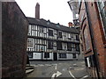
3
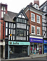
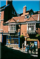
29-30 Castle Street, Shrewsbury
Pleasant combo of early C17th and early C18th, the latter the filling in a black-and-white sandwich. Grade II listed.
Occupied at the time by Lulu (flowers and interiors) and a Cancer Research UK shop.
Image: © Stephen Richards
Taken: 11 May 2014
0.02 miles
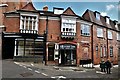
4
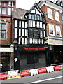
30 Castle Street, Shrewsbury
Built in the early 18th century, most likely as a house, and with the pane-glass shop front and commercial premises as a much more recent alteration, although there's a remnant cornice above the glass which suggests a previous frontage. This place was Grade II listed https://britishlistedbuildings.co.uk/101246904-30-castle-street-shrewsbury#.Yb4772jP3IU & https://historicengland.org.uk/listing/the-list/list-entry/1246904 in 1969.
Image: © Richard Law
Taken: 14 Aug 2021
0.02 miles
6
Meeting for a guided walk, Windsor Place, Shrewsbury
The shop on the left was a rear entrance to the Multiyork furniture store, 32-34 Castle Street. This went into administration in 2017, and the premises is now occupied by the Universal God Centre.
Image: © Humphrey Bolton
Taken: 18 Jun 2000
0.02 miles
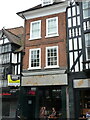
7
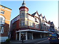
29 Castle Street, Shrewsbury
No 29 Castle Street is probably as old as its appearance suggests; it's thought to be early 17th century, and originally built as a combined shop and house, although the current shopfront is an early 20th century addition. It was Grade II listed https://britishlistedbuildings.co.uk/101271119-29-castle-street-shrewsbury#.Yb4-HWjP3IU & https://historicengland.org.uk/listing/the-list/list-entry/1271119 in 1953.
Image: © Richard Law
Taken: 14 Aug 2021
0.02 miles
8
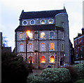
Former Church of St Nicholas, Castle Street, Shrewsbury
Image: © Dave Croker
Taken: 4 Feb 2010
0.02 miles
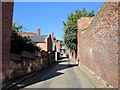
10
Water Lane
To the top of St Mary's Water Lane shut can be found a junction with Windsor Place.
Image: © J Scott
Taken: 12 Jul 2011
0.02 miles