IMAGES TAKEN NEAR TO
Criftins, ELLESMERE, SY12 9LN
Introduction
This page details the photographs taken nearby to SY12 9LN by members of the Geograph project.
The Geograph project started in 2005 with the aim of publishing, organising and preserving representative images for every square kilometre of Great Britain, Ireland and the Isle of Man.

There are currently over 7.5m images from over14,400 individuals and you can help contribute to the project by visiting https://www.geograph.org.uk
Image Map
Images are licensed for reuse under creativecommons.org/licenses/by-sa/2.0
Notes
- Clicking on the map will re-center to the selected point.
- The higher the marker number, the further away the image location is from the centre of the postcode.
Image Listing (10 Images Found)
Images are licensed for reuse under creativecommons.org/licenses/by-sa/2.0
Image
Details
Distance
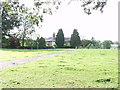
2
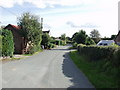
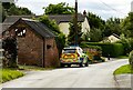
Street at Gravel Hole
Mix of older and modern housing on this rural lane.
Image: © John Haynes
Taken: 26 Sep 2006
0.08 miles
3
Dudleston Grove
Wonderful part timbered and brick traditional house.
Image: © John Haynes
Taken: 26 Sep 2006
0.14 miles
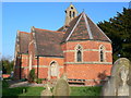
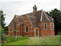
5
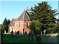
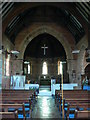
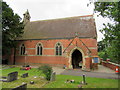
The Church of St Matthew at Criftins
Viewed from the west.
Image: © Peter Wood
Taken: 4 Dec 2016
0.18 miles
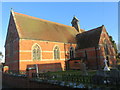
8
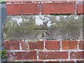
Ordnance Survey Cut Mark
This mark can be found on the wall of St Matthew's Church at Criftins.
For more detail see : http://www.bench-marks.org.uk/bm81051
Image: © Peter Wood
Taken: 4 Dec 2016
0.19 miles