IMAGES TAKEN NEAR TO
Higher Perthy, The Perthy, ELLESMERE, SY12 9HP
Introduction
This page details the photographs taken nearby to SY12 9HP by members of the Geograph project.
The Geograph project started in 2005 with the aim of publishing, organising and preserving representative images for every square kilometre of Great Britain, Ireland and the Isle of Man.

There are currently over 7.5m images from over14,400 individuals and you can help contribute to the project by visiting https://www.geograph.org.uk
Image Map
Images are licensed for reuse under creativecommons.org/licenses/by-sa/2.0
Notes
- Clicking on the map will re-center to the selected point.
- The higher the marker number, the further away the image location is from the centre of the postcode.
Image Listing (9 Images Found)
Images are licensed for reuse under creativecommons.org/licenses/by-sa/2.0
Image
Details
Distance
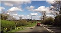
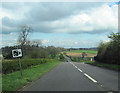
1
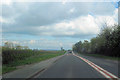
A495 east approaching The Brow
Just east of Welsh Frankton
Image: © John Firth
Taken: 14 Apr 2012
0.10 miles
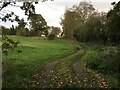
3
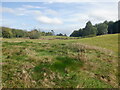
Former golf course, Welsh Frankton
Many golf courses opened around the 1990s and a lot of them did not last.
Image: © Richard Webb
Taken: 8 Oct 2021
0.18 miles
4
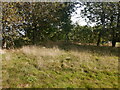
Former golf course, Welsh Frankton
Closed around 2019.
Image: © Richard Webb
Taken: 8 Oct 2021
0.19 miles
5
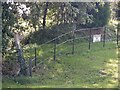
Path sign, Welsh Franklin
A common contradiction. I took solace from the fact that I would soon be back in Scotland - not that this does not happen there either.
Usually I photograph the rear of these signs.
Image: © Richard Webb
Taken: 8 Oct 2021
0.19 miles
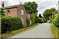
9
A495 east at entrance to The Brow Golf Club
Entrance just to the right
Image: © John Firth
Taken: 14 Apr 2012
0.23 miles