IMAGES TAKEN NEAR TO
Frankton, ELLESMERE, SY12 9HB
Introduction
This page details the photographs taken nearby to SY12 9HB by members of the Geograph project.
The Geograph project started in 2005 with the aim of publishing, organising and preserving representative images for every square kilometre of Great Britain, Ireland and the Isle of Man.

There are currently over 7.5m images from over14,400 individuals and you can help contribute to the project by visiting https://www.geograph.org.uk
Image Map
Images are licensed for reuse under creativecommons.org/licenses/by-sa/2.0
Notes
- Clicking on the map will re-center to the selected point.
- The higher the marker number, the further away the image location is from the centre of the postcode.
Image Listing (6 Images Found)
Images are licensed for reuse under creativecommons.org/licenses/by-sa/2.0
Image
Details
Distance
1
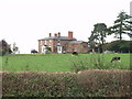
House at New Crickett
Country house with wonderful views all round.
Image: © John Haynes
Taken: 26 Sep 2006
0.05 miles
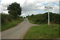
4
Fork near New Crickett
A new style of finger post in North Shropshire. Most of the surrounding land is under forage maize.
Image: © Richard Webb
Taken: 19 Oct 2014
0.13 miles
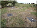
5
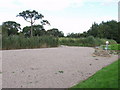
Reed Bed at Duddleston Heath sewage works
Small local sewage works with three covered airation chambers and a reed bed is operated by Severn trent Water.
Image: © John Haynes
Taken: 26 Sep 2006
0.14 miles
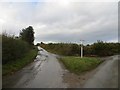
6
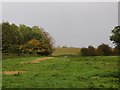
Field near New Crickett
Forage maize in the background.
Image: © Richard Webb
Taken: 19 Oct 2014
0.16 miles