IMAGES TAKEN NEAR TO
Pentrecoed, ELLESMERE, SY12 9EA
Introduction
This page details the photographs taken nearby to SY12 9EA by members of the Geograph project.
The Geograph project started in 2005 with the aim of publishing, organising and preserving representative images for every square kilometre of Great Britain, Ireland and the Isle of Man.

There are currently over 7.5m images from over14,400 individuals and you can help contribute to the project by visiting https://www.geograph.org.uk
Image Map
Images are licensed for reuse under creativecommons.org/licenses/by-sa/2.0
Notes
- Clicking on the map will re-center to the selected point.
- The higher the marker number, the further away the image location is from the centre of the postcode.
Image Listing (4 Images Found)
Images are licensed for reuse under creativecommons.org/licenses/by-sa/2.0
Image
Details
Distance
1
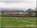
Lower Farm
A large dairy farm with mainly modern buildings.
Image: © John Haynes
Taken: 15 Mar 2007
0.03 miles
2
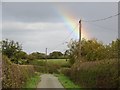
Lane, Pentre-coed
Lots of rainbows today.
Image: © Richard Webb
Taken: 19 Oct 2014
0.08 miles
4
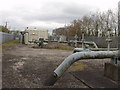
Gas National Grid pumps
Tucked away in the corner square is a compound with two gas pumps and a cleaning pig station.
Image: © John Haynes
Taken: 15 Mar 2007
0.22 miles