IMAGES TAKEN NEAR TO
The Trench, ELLESMERE, SY12 9DR
Introduction
This page details the photographs taken nearby to SY12 9DR by members of the Geograph project.
The Geograph project started in 2005 with the aim of publishing, organising and preserving representative images for every square kilometre of Great Britain, Ireland and the Isle of Man.

There are currently over 7.5m images from over14,400 individuals and you can help contribute to the project by visiting https://www.geograph.org.uk
Image Map
Images are licensed for reuse under creativecommons.org/licenses/by-sa/2.0
Notes
- Clicking on the map will re-center to the selected point.
- The higher the marker number, the further away the image location is from the centre of the postcode.
Image Listing (3 Images Found)
Images are licensed for reuse under creativecommons.org/licenses/by-sa/2.0
Image
Details
Distance
1
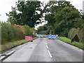
Roadworks on the A528
Between Overton and Ellesmere. Kerbs are being put along the sides of the road.
Image: © Eirian Evans
Taken: 26 Sep 2007
0.14 miles
2
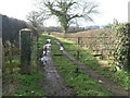
Path and Gate
This gate gives access to Plas-yn-Grove. The footpath leads to Gadlas.
Image: © Michael Patterson
Taken: 22 Feb 2007
0.18 miles