IMAGES TAKEN NEAR TO
Chapel Lane, ELLESMERE, SY12 9BS
Introduction
This page details the photographs taken nearby to Chapel Lane, SY12 9BS by members of the Geograph project.
The Geograph project started in 2005 with the aim of publishing, organising and preserving representative images for every square kilometre of Great Britain, Ireland and the Isle of Man.

There are currently over 7.5m images from over14,400 individuals and you can help contribute to the project by visiting https://www.geograph.org.uk
Image Map
Images are licensed for reuse under creativecommons.org/licenses/by-sa/2.0
Notes
- Clicking on the map will re-center to the selected point.
- The higher the marker number, the further away the image location is from the centre of the postcode.
Image Listing (7 Images Found)
Images are licensed for reuse under creativecommons.org/licenses/by-sa/2.0
Image
Details
Distance
1
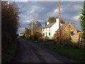
Cottage with a fresh coat of paint
Very neat and tidy cottage in Bagley.
Image: © John Haynes
Taken: 11 Dec 2007
0.02 miles
2
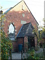
Converted chapel at Bagley
Another Primitive Methodist chapel, having undergone a conversion.
Image: © Eirian Evans
Taken: 23 Oct 2007
0.05 miles
3
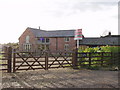
Barn conversion on the edge of Bagley
The demand for steading conversions in Shropshire is un-ending. There are many wonderful brick built barns and cheese stores that are ripe for conversion.
Image: © John Haynes
Taken: 11 Dec 2007
0.09 miles
4
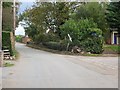
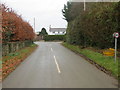
Bagley
A road junction in Bagley, land just above the surrounding moor.
Image: © Richard Webb
Taken: 19 Oct 2014
0.09 miles
5
Junction of roads in Bagley
Looking northward.
Image: © Peter Wood
Taken: 3 Dec 2016
0.09 miles
6
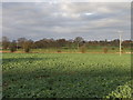
Oil Seed Rape on the edge of Bagley
Mixed arable and livestock in this area so this field could be grass or arable. This year it's oil seed, but the field beyond is grass at present grazing sheep.
Image: © John Haynes
Taken: 11 Dec 2007
0.21 miles
7
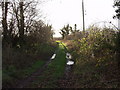
Green lane at Bagley
This green lane is used to access fields on the Baggy Moor.
Image: © John Haynes
Taken: 11 Dec 2007
0.21 miles