IMAGES TAKEN NEAR TO
Colemere, ELLESMERE, SY12 0QL
Introduction
This page details the photographs taken nearby to SY12 0QL by members of the Geograph project.
The Geograph project started in 2005 with the aim of publishing, organising and preserving representative images for every square kilometre of Great Britain, Ireland and the Isle of Man.

There are currently over 7.5m images from over14,400 individuals and you can help contribute to the project by visiting https://www.geograph.org.uk
Image Map
Images are licensed for reuse under creativecommons.org/licenses/by-sa/2.0
Notes
- Clicking on the map will re-center to the selected point.
- The higher the marker number, the further away the image location is from the centre of the postcode.
Image Listing (37 Images Found)
Images are licensed for reuse under creativecommons.org/licenses/by-sa/2.0
Image
Details
Distance
1
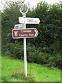
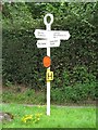
Old Direction Sign - Signpost in Colemere, Wem Rural Parish
Annulus finial - 3 arms; Shropshire CC modern halo by the UC road, in parish of Wem Rural (North Shropshire District), Colemere 2.
Surveyed
Milestone Society National ID: SA_SJ4332E.
Image: © Milestone Society
Taken: Unknown
0.07 miles
2
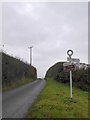
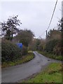
Road junction in Colemere
Traffic for the country park is taken to the right, although the left fork is a shorter route. The signpost is marked with the name "Colemere" on the circle
Image: © David Smith
Taken: 28 Nov 2014
0.08 miles
3
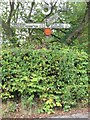
Old Direction Sign - Signpost by The Smithy, Colemere
Annulus finial - 3 arms; Shropshire CC halo by the UC road, in parish of Wem Rural (North Shropshire District), Colemere.
Shropshire HER.
HER Number (PRN): 31190 https://www.heritagegateway.org.uk/Gateway/Results_Single.aspx?uid=MSA34029&resourceID=1015
Surveyed
Milestone Society National ID: SA_SJ4332B
Image: © Milestone Society
Taken: Unknown
0.09 miles
4
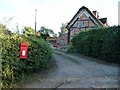
Postbox at Colemere
Near a road junction at the north end of the village. The village is Colemere, the nearby lake Cole Mere.
Image: © Christine Johnstone
Taken: 17 Sep 2016
0.09 miles
5
Old Direction Sign - Signpost west of Colemere
Annulus finial - 4 arms; Shropshire CC modern halo by the UC road, in parish of Wem Rural (North Shropshire District), Colemere 1.
Surveyed
Milestone Society National ID: SA_SJ4332C
Image: © Milestone Society
Taken: Unknown
0.10 miles
6
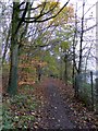
Footpath in the woods by Cole Mere
A suggested route in the country park
Image: © David Smith
Taken: 28 Nov 2014
0.11 miles
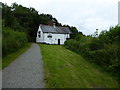
7
The Boat House, Colemere
The mere is regularly used by Colemere sailing club.
Image: © David Dixon
Taken: 3 Jun 2019
0.11 miles
8
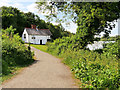
Minor road north of Colemere
This road leads from the centre of Colemere to the western end of Cole Mere itself
Image: © David Smith
Taken: 28 Nov 2014
0.11 miles
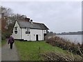
9
Cole Mere Sailing Club boathouse
This is near the southern tip of the lake.
Image: © Eirian Evans
Taken: 16 Jul 2016
0.11 miles
10
Boathouse on Cole Mere
A boathouse for the sailing club; the footpath runs around the mere, one of the suggested routes in the country park
Image: © David Smith
Taken: 28 Nov 2014
0.11 miles