IMAGES TAKEN NEAR TO
Church Green, ELLESMERE, SY12 0LH
Introduction
This page details the photographs taken nearby to Church Green, SY12 0LH by members of the Geograph project.
The Geograph project started in 2005 with the aim of publishing, organising and preserving representative images for every square kilometre of Great Britain, Ireland and the Isle of Man.

There are currently over 7.5m images from over14,400 individuals and you can help contribute to the project by visiting https://www.geograph.org.uk
Image Map
Images are licensed for reuse under creativecommons.org/licenses/by-sa/2.0
Notes
- Clicking on the map will re-center to the selected point.
- The higher the marker number, the further away the image location is from the centre of the postcode.
Image Listing (32 Images Found)
Images are licensed for reuse under creativecommons.org/licenses/by-sa/2.0
Image
Details
Distance
2
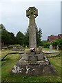
Cockshutt war memorial
Cockshutt war memorial stands in the churchyard.
Image: © Philip Halling
Taken: 1 Jun 2018
0.04 miles
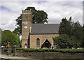
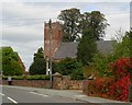
4
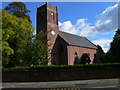
The Church of St Simon & St Jude, Cockshutt
Image: © Eirian Evans
Taken: 26 Sep 2007
0.04 miles
5
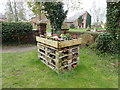
Bee & bug housing at St Simon & St Jude's churchyard
Built of wooden pallets and with a floral display on the top
Image: © Eirian Evans
Taken: 7 Apr 2019
0.04 miles
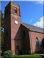
6
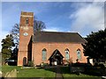
Parish Church of St Simon and St Jude, Cockshutt
Image: © John H Darch
Taken: 29 Jan 2020
0.04 miles
8
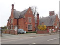
Cockshutt Post Office
The post office seems to be attached to the Primary School
Image: © Eirian Evans
Taken: 7 Apr 2019
0.05 miles
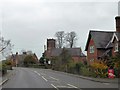
10
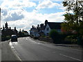
Shrewsbury Road, Cockshutt
The A528 Ellesmere to Shrewsbury Road going through Cockshutt.
Image: © Eirian Evans
Taken: 26 Sep 2007
0.05 miles