IMAGES TAKEN NEAR TO
English Frankton, ELLESMERE, SY12 0JU
Introduction
This page details the photographs taken nearby to SY12 0JU by members of the Geograph project.
The Geograph project started in 2005 with the aim of publishing, organising and preserving representative images for every square kilometre of Great Britain, Ireland and the Isle of Man.

There are currently over 7.5m images from over14,400 individuals and you can help contribute to the project by visiting https://www.geograph.org.uk
Image Map
Images are licensed for reuse under creativecommons.org/licenses/by-sa/2.0
Notes
- Clicking on the map will re-center to the selected point.
- The higher the marker number, the further away the image location is from the centre of the postcode.
Image Listing (4 Images Found)
Images are licensed for reuse under creativecommons.org/licenses/by-sa/2.0
Image
Details
Distance
2
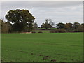
Fields and trees looking good
What a view, winter crops growing well, trees moving towards autumn splendour. Truly the season of mellow fruitfulness.
Image: © John Haynes
Taken: 30 Oct 2007
0.17 miles
3
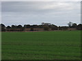
Winter wheat near English Frankton
Walking across the footpath to English Frankton you cross large arable fields.
Image: © John Haynes
Taken: 30 Oct 2007
0.20 miles
