IMAGES TAKEN NEAR TO
Dairy Grove, ELLESMERE, SY12 0GA
Introduction
This page details the photographs taken nearby to Dairy Grove, SY12 0GA by members of the Geograph project.
The Geograph project started in 2005 with the aim of publishing, organising and preserving representative images for every square kilometre of Great Britain, Ireland and the Isle of Man.

There are currently over 7.5m images from over14,400 individuals and you can help contribute to the project by visiting https://www.geograph.org.uk
Image Map
Images are licensed for reuse under creativecommons.org/licenses/by-sa/2.0
Notes
- Clicking on the map will re-center to the selected point.
- The higher the marker number, the further away the image location is from the centre of the postcode.
Image Listing (214 Images Found)
Images are licensed for reuse under creativecommons.org/licenses/by-sa/2.0
Image
Details
Distance
2

Nan's Treasure Box, Ellesmere
On Wharf Road.
Image: © Richard Webb
Taken: 5 Jul 2018
0.04 miles
6
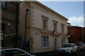
Ellesmere: former bank on Scotland Street
Image: © Christopher Hilton
Taken: 12 Sep 2020
0.06 miles
7
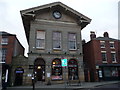
Ellesmere Town Hall
A very handsome building in the old town centre.
Image: © Jeremy Bolwell
Taken: 27 Dec 2011
0.06 miles
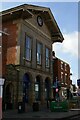
10
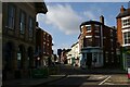
Ellesmere, the town centre
On the left is the former town hall.
Image: © Christopher Hilton
Taken: 12 Sep 2020
0.07 miles