IMAGES TAKEN NEAR TO
St. Marys Court, ELLESMERE, SY12 0FR
Introduction
This page details the photographs taken nearby to St. Marys Court, SY12 0FR by members of the Geograph project.
The Geograph project started in 2005 with the aim of publishing, organising and preserving representative images for every square kilometre of Great Britain, Ireland and the Isle of Man.

There are currently over 7.5m images from over14,400 individuals and you can help contribute to the project by visiting https://www.geograph.org.uk
Image Map
Images are licensed for reuse under creativecommons.org/licenses/by-sa/2.0
Notes
- Clicking on the map will re-center to the selected point.
- The higher the marker number, the further away the image location is from the centre of the postcode.
Image Listing (178 Images Found)
Images are licensed for reuse under creativecommons.org/licenses/by-sa/2.0
Image
Details
Distance
1
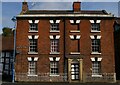
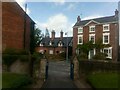
Ellesmere: house on Church Street
This building, Beaumont, dates from the early nineteenth century, and is Grade II listed: https://britishlistedbuildings.co.uk/101055542-beaumont-ellesmere-urban#.X30DzFKSk2w .
Image: © Christopher Hilton
Taken: 12 Sep 2020
0.03 miles
2
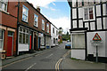
St John's Hill, Ellesmere 2008
Looking up St John's Hill from Birch Road.
Image: © John Randall Lewis
Taken: 29 Apr 2008
0.03 miles
3
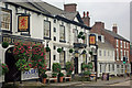
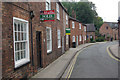
Red Lion Coaching Inn, Ellesmere
Large 16th century inn on Church Street.
Image: © Stephen McKay
Taken: 6 Oct 2008
0.04 miles
4
The Red Lion, Ellesmere, Shropshire
An historic coaching inn with St. Mary's church behind it.
Image: © Jeremy Bolwell
Taken: 27 Dec 2011
0.04 miles
5
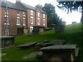
Ellesmere: houses on Church Street, from the churchyard
Image: © Christopher Hilton
Taken: 12 Sep 2020
0.05 miles
6
Watergate Street, Ellesmere
Atmospheric Watergate Street connects Church Street with High Street; it is seen here from the Church Street junction.
Image: © Stephen McKay
Taken: 6 Oct 2008
0.05 miles
7
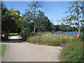
Entrance to the park
Designed as a 19th century pleasure ground, the attractive park sweeps down to the lake. In 2007 a Heritage Lottery funded project will be started to improve it - let's hope it retains its character.
Image: © Trevor Rickard
Taken: 8 Aug 2007
0.06 miles
8
Ellesmere: houses on Church Street, from the churchyard
Image: © Christopher Hilton
Taken: 12 Sep 2020
0.07 miles
9
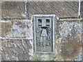
Ordnance Survey Flush Bracket S5841
This can be found on the wall of St Mary's Church in Ellesmere.
For more detail see : http://www.bench-marks.org.uk/bm15026
Image: © Peter Wood
Taken: 5 Dec 2016
0.07 miles
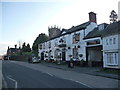
10
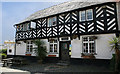
The White Hart Inn, Ellesmere
The White Hart Inn public house is a grade 2 listed building situated on Birch Road near the town centre. Built in early 17th century with later timber frame and plaster infilling. Home to the Lewis family in the late 19th century.
Image: © John Randall Lewis
Taken: 29 Apr 2008
0.07 miles