IMAGES TAKEN NEAR TO
St. Johns Hill, ELLESMERE, SY12 0EZ
Introduction
This page details the photographs taken nearby to St. Johns Hill, SY12 0EZ by members of the Geograph project.
The Geograph project started in 2005 with the aim of publishing, organising and preserving representative images for every square kilometre of Great Britain, Ireland and the Isle of Man.

There are currently over 7.5m images from over14,400 individuals and you can help contribute to the project by visiting https://www.geograph.org.uk
Image Map
Images are licensed for reuse under creativecommons.org/licenses/by-sa/2.0
Notes
- Clicking on the map will re-center to the selected point.
- The higher the marker number, the further away the image location is from the centre of the postcode.
Image Listing (224 Images Found)
Images are licensed for reuse under creativecommons.org/licenses/by-sa/2.0
Image
Details
Distance
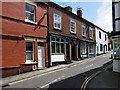
1
Path through the churchyard, Ellesmere
Image: © Ruth Sharville
Taken: 19 Oct 2018
0.02 miles
2
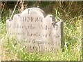
Gravestone and Red Admiral butterfly, Ellesmere churchyard
Mary Leeke, whose grave this is, lived nearby at Cole Mere (one of the kettlehole lakes that give this area the name of the Shropshire Lake District).
Image: © Christopher Hilton
Taken: 12 Sep 2020
0.05 miles
3
St John's Hill, Ellesmere
Looking down the hill towards the town centre.
Image: © Stephen McKay
Taken: 10 Jul 2018
0.05 miles
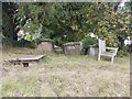
4
WWII Cheshire: Ellesmere (defended locality) road block (2)
-
Anti-tank Vertical Rails: EDoB ID: e09388
Ellesmere was a 'Defended Locality' during WW2 when there were at least 10 such anti-tank road blocks in the town, all traces of them bar this one (the sole survivor), having been removed. I was amused by the peacetime use for some of the concrete bases here.
Image: © Mike Searle
Taken: 21 Jun 2019
0.05 miles
5
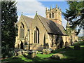
St Mary's Church, Ellesmere
The parish church of the Blessed Virgin Mary, viewed from the south-west. It was originally a Norman church, and was rebuilt and restored by Sir George Gilbert Scott in the 1840s.
Image: © David Weston
Taken: 2 Oct 2014
0.05 miles
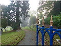
6
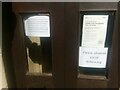
Ellesmere church: signs setting out Coronavirus restrictions
Image: © Christopher Hilton
Taken: 12 Sep 2020
0.05 miles
7

Ellesmere church: signs setting out Coronavirus restrictions
Image: © Christopher Hilton
Taken: 12 Sep 2020
0.05 miles
8
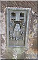
Ordnance Survey Flush Bracket (S5841)
This OS Flush Bracket can be found on the NW face of St Mary's Church. It marks a point 98.025m above mean sea level.
Image: © Adrian Dust
Taken: 30 Sep 2016
0.05 miles