1
Canal Way in Ellesmere
Looking south-eastward.
Image: © Peter Wood
Taken: 5 Dec 2016
0.06 miles
2
Curious House
A large house, of various architectural styles, on the main A495 road out of Ellesmere towards Oswestry.
Image: © Howard Selina
Taken: 3 Oct 2007
0.07 miles
3
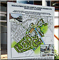
Redevelopment at the wharf, Ellesmere
This former creamery site is now being redeveloped into a retail and residential area by Pochin Developments.
This http://www.geograph.org.uk/photo/1358284 shows the plans.
Image: © Dave Croker
Taken: 13 Jun 2009
0.08 miles
4
The Changing Face Of Ellesmere
Where once stood a dairy now stands Tesco, but is this a bad thing?
Image: © Mr M Evison
Taken: 22 Aug 2009
0.08 miles
5
Redevelopment sign, Ellesmere.
This http://www.geograph.org.uk/photo/1358280 shows the work in progress.
Image: © Dave Croker
Taken: 13 Jun 2009
0.09 miles
6
Ordnance Survey Flush Bracket (G3040)
This OS Flush Bracket can be found on No46 Scotland Road. It marks a point 92.796m above mean sea level.
Image: © Adrian Dust
Taken: 21 Feb 2022
0.10 miles
7
Autumn Sunrise, Canal Basin, Ellesemere, Shropshire
This view will sadly disappear when the much needed supermarket is built in 2009. The shot is taken standing by the old allotments next to the canal wharf, early November 2008.
Image: © Sandra Oxley
Taken: 7 Nov 2008
0.10 miles
8
Ordnance Survey Flush Bracket G3040
This can be found on the roadside wall of a building in Scotland Street, Ellesmere.
For more detail see : http://www.bench-marks.org.uk/bm15025
Image: © Peter Wood
Taken: 5 Dec 2016
0.10 miles
9
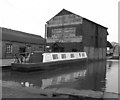
Canal warehouse, Ellesmere Basin, Llangollen Canal
The former canal company's name is painted on the end of the warehouse. Latterly before nationalisation in 1948, the company was owned by the LMS railway.
Image: © Dr Neil Clifton
Taken: 10 Apr 1979
0.11 miles
10
Ellesmere Canal Wharf
Image: © Mr M Evison
Taken: 16 Jul 2011
0.11 miles


