IMAGES TAKEN NEAR TO
Sparbridge, ELLESMERE, SY12 0AS
Introduction
This page details the photographs taken nearby to SY12 0AS by members of the Geograph project.
The Geograph project started in 2005 with the aim of publishing, organising and preserving representative images for every square kilometre of Great Britain, Ireland and the Isle of Man.

There are currently over 7.5m images from over14,400 individuals and you can help contribute to the project by visiting https://www.geograph.org.uk
Image Map
Images are licensed for reuse under creativecommons.org/licenses/by-sa/2.0
Notes
- Clicking on the map will re-center to the selected point.
- The higher the marker number, the further away the image location is from the centre of the postcode.
Image Listing (155 Images Found)
Images are licensed for reuse under creativecommons.org/licenses/by-sa/2.0
Image
Details
Distance
1
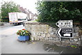
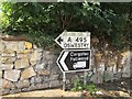
Road Sign, Ellesmere
This old fashioned road sign indicating the route of the A495 to Oswestry is at the southern end of Grange Rd close to the junction with Willow St and Talbot St.
Image: © Nigel Mykura
Taken: 1 Sep 2015
0.01 miles
3
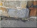
Ordnance Survey Cut Mark
This OS cut mark can be found on the outbuilding of No1 Sparbridge. It marks a point 91.288m above mean sea level.
Image: © Adrian Dust
Taken: 21 Feb 2022
0.01 miles
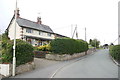
4
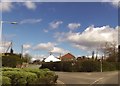
Swan Hill Ellesmere
From the A495. This is the road to the cemetery
Image: © John Firth
Taken: 11 Apr 2015
0.02 miles
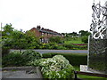
7
Swan Hill
Swan hill runs from the centre of Ellesmere at the western end of Talbot St along the northern side of The Mere. It has a wide range of old and new properties.
Image: © Nigel Mykura
Taken: 1 Sep 2015
0.04 miles
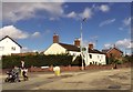
8
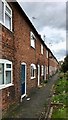
Charlotte Row
Often referred to as a 'Victorian' terrace though the name suggests a slightly earlier date.
Image: © John H Darch
Taken: 1 May 2018
0.04 miles
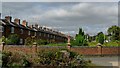
9
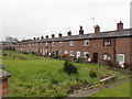
Terraced houses, Grange Road
On the northern approach to Ellesmere.
Image: © Eirian Evans
Taken: 7 Apr 2019
0.04 miles
10
Ellesmere: pre-Worboys sign at junction of Willow Street and Brownlow Road
Image: © Jonathan Hutchins
Taken: 25 Jul 2015
0.05 miles