IMAGES TAKEN NEAR TO
Belmont Bank, SHREWSBURY, SY1 1UA
Introduction
This page details the photographs taken nearby to Belmont Bank, SY1 1UA by members of the Geograph project.
The Geograph project started in 2005 with the aim of publishing, organising and preserving representative images for every square kilometre of Great Britain, Ireland and the Isle of Man.

There are currently over 7.5m images from over14,400 individuals and you can help contribute to the project by visiting https://www.geograph.org.uk
Image Map
Images are licensed for reuse under creativecommons.org/licenses/by-sa/2.0
Notes
- Clicking on the map will re-center to the selected point.
- The higher the marker number, the further away the image location is from the centre of the postcode.
Image Listing (1576 Images Found)
Images are licensed for reuse under creativecommons.org/licenses/by-sa/2.0
Image
Details
Distance
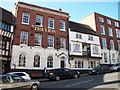
2
Plaque on Sabrina View House - 1878
Sabrina View House is on the corner of Wyle Cop and Belmont Bank. The plaque declares that the house was built in 1878.
Image: © John S Turner
Taken: 7 May 2009
0.01 miles
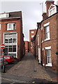
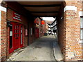
3
Belmont Bank from Beeches Lane
Looking across Beeches Lane towards Belmont Bank. The house on the right is Sabrina View House, and on the left, London House.
Image: © John S Turner
Taken: 7 May 2009
0.01 miles
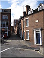
4
Belmont Bank, Shrewsbury
Belmont Bank is the lane where Town Walls on its left side becomes Beeches Lane on its right.
Image: © Jaggery
Taken: 15 Oct 2013
0.01 miles
5
Casa Naranjo in Shrewsbury
Tapas bar and restaurant in Barracks Passage, viewed from Belmont Bank.
Image: © Jaggery
Taken: 31 May 2014
0.01 miles
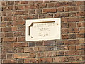
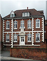
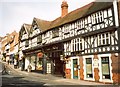
7
Bowdler's House Dental Practice, Shrewsbury
Viewed from Beeches Lane. Despite the name of the dental practice, this building was originally Bowlder's School. The stone above the doorway shows Founded by Thomas Bowdler 1724.
Image: © Jaggery
Taken: 15 Oct 2013
0.02 miles
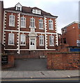
8
Former school, Town Walls, Shrewsbury
Built as Bowdler's School in 1724, its charmingly crowded facade typical of the date. Grade II listed.
Now it appears to house a dental practice and flats.
Image: © Stephen Richards
Taken: 11 May 2014
0.02 miles
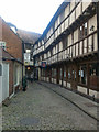
9
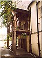
Screens passage of Nag's Head Hall, Wyle Cop, Shrewsbury
This is the only surviving part of a 14C hall-house, behind the nag's Head Inn. The roof is supported by a spere-truss, behind which is the screens passage on the ground floor with three service doorways.
Image: © Humphrey Bolton
Taken: 15 Sep 2001
0.02 miles
10
Building opposite the Lion Hotel, Wyle Cop, Shrewsbury
This building dates from c.1920, when the junction with Dogpole (the road up to the left seen in another photo), was widened. The shop front must be of that period, but the brick wall to the right looks out-of-place.
Image: © Humphrey Bolton
Taken: 15 Sep 2001
0.02 miles