IMAGES TAKEN NEAR TO
Beeches Lane, SHREWSBURY, SY1 1TG
Introduction
This page details the photographs taken nearby to Beeches Lane, SY1 1TG by members of the Geograph project.
The Geograph project started in 2005 with the aim of publishing, organising and preserving representative images for every square kilometre of Great Britain, Ireland and the Isle of Man.

There are currently over 7.5m images from over14,400 individuals and you can help contribute to the project by visiting https://www.geograph.org.uk
Image Map
Images are licensed for reuse under creativecommons.org/licenses/by-sa/2.0
Notes
- Clicking on the map will re-center to the selected point.
- The higher the marker number, the further away the image location is from the centre of the postcode.
Image Listing (1513 Images Found)
Images are licensed for reuse under creativecommons.org/licenses/by-sa/2.0
Image
Details
Distance
2
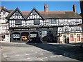
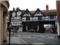
46-48 Wyle Cop, Shrewsbury
Dated c1800, the return to St Julians Crescent made into a proper front. Grade II listed.
The ghost sign has been overwritten, but refers to "Cycles / Motorcycles / Tyres / Velocette / Lington Cycle Cars".
Image: © Stephen Richards
Taken: 11 May 2014
0.00 miles
3
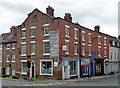
The County Sleep Shop in Shrewsbury
Viewed across Beeches Lane. The nameboard on the side wall shows
that the bed and nursery specialists business was established in 1956.
Image: © Jaggery
Taken: 15 Oct 2013
0.01 miles
4
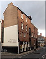
The Cornhouse, Shrewsbury
Bar & eatery on the corner of Wyle Cop and St Julian's Friars.
Image: © Jaggery
Taken: 31 May 2014
0.01 miles
5
Wine merchant in Wyle Cop
Magnificent Tudor building has housed this family business for around 160 years and its unchanged cellars are described as Dickensian.
This view from the entrance to St Julian Friars is framed by the old Cornhouse on the right and. on the left, Century House, which in the C14 was the location of several small 'messuages' or dwellings, and subsequently the site of a malthouse, a leadworks, an iron foundry, and an ironmongery. In 1913 it became the Kings Hall Cinema and later the Century Cinema. Recently it has been converted into residential and commercial units, retaining its cinematic facade.
Image: © Natasha Ceridwen de Chroustchoff
Taken: 3 Feb 2010
0.01 miles
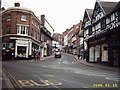
6
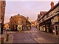
Wyle Cop in Shrewsbury
The junction of Wyle Cop and Beeches Lane in Shrewsbury on a Sunday morning before people and traffic are about.
Image: © Peter Evans
Taken: 22 Jan 2023
0.01 miles
7
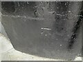
Ordnance Survey Cut Mark
This OS cut mark can be found on No60 Wyle Cop. It marks a point 53.467m above mean sea level.
Image: © Adrian Dust
Taken: 3 Jul 2023
0.01 miles
8

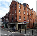
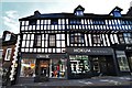
60 Wyle Cop, Shrewsbury
The Georgians handled corners really well. This early C19th job rounds the junction with Beeches Lane. Grade II listed.
Occupied at the time by The County Sleep Shop.
Image: © Stephen Richards
Taken: 11 May 2014
0.01 miles
9
Shrewsbury, Wyle Cop: Oberon boutique and Hokum hair and beauty
Image: © Michael Garlick
Taken: 30 Apr 2019
0.01 miles
10
Wyle Cop Shrewsbury On A Sunday Afternoon
Image: © Mr M Evison
Taken: 15 Jan 2006
0.01 miles