IMAGES TAKEN NEAR TO
St. Austins Friars, SHREWSBURY, SY1 1RY
Introduction
This page details the photographs taken nearby to St. Austins Friars, SY1 1RY by members of the Geograph project.
The Geograph project started in 2005 with the aim of publishing, organising and preserving representative images for every square kilometre of Great Britain, Ireland and the Isle of Man.

There are currently over 7.5m images from over14,400 individuals and you can help contribute to the project by visiting https://www.geograph.org.uk
Image Map
Images are licensed for reuse under creativecommons.org/licenses/by-sa/2.0
Notes
- Clicking on the map will re-center to the selected point.
- The higher the marker number, the further away the image location is from the centre of the postcode.
Image Listing (1035 Images Found)
Images are licensed for reuse under creativecommons.org/licenses/by-sa/2.0
Image
Details
Distance
1
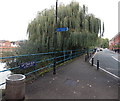
Romolo, Shrewsbury
Restaurant and lounge bar on the south bank of the River Severn at Victoria Quay, Victoria Avenue.
Image: © Jaggery
Taken: 15 Oct 2013
0.02 miles
2
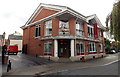
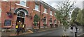
Former Armoury, Victoria Quay, Shrewsbury
Built in 1806 as barracks to the designs of James Wyatt no less. Wyatt's imposing building stood in London Road; it was dismantled and re-assembled in its present location in 1919 when it operated as Morris & Co.'s bakery. Grade II listed.
Now back to The Armoury in its current incarnation as a pub.
Image: © Stephen Richards
Taken: 12 May 2014
0.02 miles
3
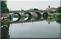
Welsh Bridge, Shrewsbury
1795 bridge over the River Severn.
Image: © Richard Sutcliffe
Taken: Unknown
0.02 miles
4
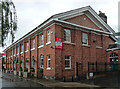
'The Armoury' restaurant & bar
A Grade II listed building http://www.britishlistedbuildings.co.uk/101254936-bakery-shrewsbury#.WQNmAdQrLGg with a long & varied history. Originally built as a barracks on a site between London Road and Wenlock Road in Image in 1806, it was moved to the current location and rebuilt as a bakery in the early 20th century (1920s). The listed status was awarded as late as 1994, and the original site is still recognised by a road named Armoury Gardens.
Image: © Richard Law
Taken: 8 Apr 2017
0.03 miles
5
Victoria Quay, Victoria Avenue, Shrewsbury
Looking east along the south bank of the River Severn.
Image: © Jaggery
Taken: 15 Oct 2013
0.03 miles
7
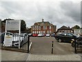
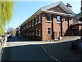
Shrewsbury Sixth Form College
Welsh Bridge Campus. The Grade II listed https://historicengland.org.uk/listing/the-list/list-entry/1254737 Shrewsbury Sixth Form College was originally the Priory School for Boys.
Image: © Gerald England
Taken: 21 Jul 2019
0.03 miles
8
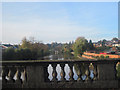
River Severn from Welsh Bridge
Looking upstream
Image: © John Firth
Taken: 1 Nov 2010
0.03 miles
9
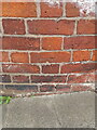
Possible OS benchmark - 8 St Austins Street
The maps show a benchmark here, and this has (almost) all the appearance of one, except that the 'crowsfoot' part only has 2 legs rather than the conventional 3. If it IS such a mark, then it was cut in 1967 and levelled at 54.588m above Ordnance Datum Newlyn. On the other hand, it may be some sort of mason's mark, similar to a couple of others in the town, such as Image
Image: © Richard Law
Taken: 26 Aug 2024
0.03 miles
10
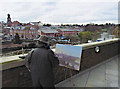
Painting the Welsh Bridge
The Theatre Severn is a great viewpoint, as this painter found out.
Image: © Dave Croker
Taken: 17 Dec 2009
0.03 miles