IMAGES TAKEN NEAR TO
Claremont Bank, SHREWSBURY, SY1 1RJ
Introduction
This page details the photographs taken nearby to Claremont Bank, SY1 1RJ by members of the Geograph project.
The Geograph project started in 2005 with the aim of publishing, organising and preserving representative images for every square kilometre of Great Britain, Ireland and the Isle of Man.

There are currently over 7.5m images from over14,400 individuals and you can help contribute to the project by visiting https://www.geograph.org.uk
Image Map
Images are licensed for reuse under creativecommons.org/licenses/by-sa/2.0
Notes
- Clicking on the map will re-center to the selected point.
- The higher the marker number, the further away the image location is from the centre of the postcode.
Image Listing (1143 Images Found)
Images are licensed for reuse under creativecommons.org/licenses/by-sa/2.0
Image
Details
Distance
1
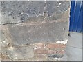
Ordnance Survey Cut Mark
This OS cut mark can be found on the wall of Claremont Buildings on Claremont Bank. It marks a point 62.449m above mean sea level.
Image: © Adrian Dust
Taken: 3 Jul 2023
0.01 miles
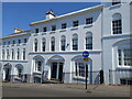
2
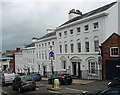
1-8 Claremont Bank, Shrewsbury
An urbane group of four blocks, each containing two three-bay houses having a shared entrance. Early C19th. Grade II listed.
Image: © Stephen Richards
Taken: 11 May 2014
0.01 miles
3
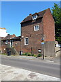
St. Chad's Cottage, Shrewsbury
A rather unusual, mid 18th century house. It consists of 2 storeys plus attic, but may well have a cellar too, and is arranged between this tall section, the block with the steps and front door, plus the annexe further left again. Grade II listed https://britishlistedbuildings.co.uk/101246914-st-chads-cottage-shrewsbury & https://historicengland.org.uk/listing/the-list/list-entry/1246914 in 1972.
Image: © Richard Law
Taken: 4 Jun 2023
0.01 miles
4
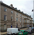
Claremont Buildings, Claremont Bank, Shrewsbury
A terrace of 1792-94, by Carline & Tilley, of some severity. If finished, it would have had a four-bay projection at the far end to complete the symmetry. The unfortunate porches are probably later. Grade II listed.
Image: © Stephen Richards
Taken: 11 May 2014
0.02 miles
5
3 & 4 Claremont Bank, Shrewsbury
Nos 3 & 4 lie near the middle of a terrace of very striking, mid 19th century, Georgian town houses (they were built around 1830) which have now mostly been converted to offices, The righthand end, including these two and the railings, was listed Grade II* https://britishlistedbuildings.co.uk/101271084-1-8-claremont-bank-and-attached-railings-shrewsbury & https://historicengland.org.uk/listing/the-list/list-entry/1271084 in 1953, and the far end was added to the listing in the late 1960s.
Image: © Richard Law
Taken: 4 Jun 2023
0.03 miles
6
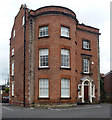
Claremont House, Claremont Bank, Shrewsbury
A fine early C18th house (e.g. see the gabled return), aggrandised later in the C18th by the addition of a full-height bow and pedimented doorcase. Grade II listed.
Originall St Chad's vicarage, it is now home to a GP surgery.
Image: © Stephen Richards
Taken: 11 May 2014
0.03 miles
7
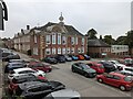
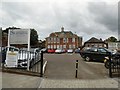
Shrewsbury Sixth Form College
Image: © TCExplorer
Taken: 7 Sep 2024
0.04 miles
8
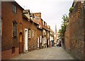
Claremont Hill, Shrewsbury
This is a narrow street of cottagey houses. The alignment on St Mary's Church might not be accidental. The houses in the photo are all listed buildings, and are 17C timber-framed buildings encased in brick in the 18C. On the left the bow windows are a 20C alteration. The arched opening to the passage to the rear has a high relieving arch over it. The square opening under the right-hand window might be a cellar vent. The next two shows signs of alterations, with relieving arches showing the position of former windows or doors. Then the houses under the mansard roof, a later alteration, may originally have been a single house (two of the present houses are at the rear, accessed via the wide archway). There are cellar windows at pavement level. This building can be seen more clearly in http://www.imagesofengland.org.uk/images/45/61/L456141.jpg
Image: © Humphrey Bolton
Taken: 15 Sep 2001
0.04 miles
9
Shrewsbury Sixth Form College
Welsh Bridge Campus. The Grade II listed https://historicengland.org.uk/listing/the-list/list-entry/1254737 Shrewsbury Sixth Form College was originally the Priory School for Boys.
Image: © Gerald England
Taken: 21 Jul 2019
0.04 miles
10
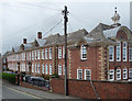
Former school, Priory Road, Shrewsbury
A good example of the William and Mary style, it was built as a secondary school by Frank Shayler & J.A. Swan, 1910-11. Grade II listed.
Now Shrewsbury Sixth Form College.
Image: © Stephen Richards
Taken: 11 May 2014
0.04 miles