IMAGES TAKEN NEAR TO
Chester Street, SHREWSBURY, SY1 1PX
Introduction
This page details the photographs taken nearby to Chester Street, SY1 1PX by members of the Geograph project.
The Geograph project started in 2005 with the aim of publishing, organising and preserving representative images for every square kilometre of Great Britain, Ireland and the Isle of Man.

There are currently over 7.5m images from over14,400 individuals and you can help contribute to the project by visiting https://www.geograph.org.uk
Image Map
Images are licensed for reuse under creativecommons.org/licenses/by-sa/2.0
Notes
- Clicking on the map will re-center to the selected point.
- The higher the marker number, the further away the image location is from the centre of the postcode.
Image Listing (1071 Images Found)
Images are licensed for reuse under creativecommons.org/licenses/by-sa/2.0
Image
Details
Distance
1
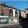
Albion Vaults and Shrewsbury Ark, Shrewsbury
Pub with accommodation at 12 Castle Foregate.
On the left, Shrewsbury Ark is a drop-in centre helping homeless and vulnerable people.
Image: © Jaggery
Taken: 15 Oct 2013
0.02 miles
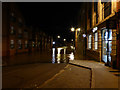
2
CCTV Surveillance Zone, Castle Foregate, Shrewsbury
Two CCTV cameras on poles are in view, one on the left and one on the right,
between the Albion Vaults pub http://www.geograph.org.uk/photo/4741974 out of shot on the left
and a railway bridge on the right near Shrewsbury railway station.
Out of shot, a notice on the wall behind the left side camera shows
This area is covered by Closed Circuit Television Surveillance.
Shrewsbury and Atcham Borough Council in partnership with West Mercia Constabulary.
Making the Town Centre a Safer Place.
Image: © Jaggery
Taken: 16 Nov 2015
0.02 miles
3
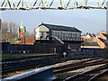
Crewe Junction signal box
At the north end of Shrewsbury station, controls the routes to Crewe and Wrexham. It is one of four boxes surviving in the immediate Shrewsbury area, the others being Severn Bridge Junction, Sutton Bridge Junction and Abbey Foregate Junction.
Image: © John Lucas
Taken: 6 Jan 2016
0.02 miles
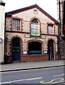
4

The Butter Market Nightclub
This is a former warehouse for the Shrewsbury Canal
Image: © Mr M Evison
Taken: 13 Nov 2005
0.02 miles
5
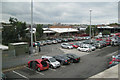
Shrewsbury station pay-and-display car park
Seen from Beacall's Lane. Operated by Arriva Trains.
Image: © Robin Stott
Taken: 16 Oct 2010
0.02 miles
6
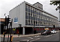
Cambrian Business Centre, Shrewsbury
Office block dating from c1970, on the corner of Chester Street (on the right) and Cross Street.
The location is within a flood risk area near the River Severn. There are no offices on the ground floor where there is only the reception and plant room, which is protected by a flood barrier.
Image: © Jaggery
Taken: 31 May 2014
0.02 miles
7
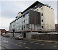
Scaffolding on Cambrian House, Shrewsbury
Viewed across Chester Street on December 1st 2015. In May 2015, the Shropshire Star reported that the former office block Cambrian House is being radically altered in a £3 million scheme which will see it transformed into 21 two and three bedroom apartments, including four penthouses. The building is being totally stripped back internally before being rebuilt and then reclad with a mixture of oak panelling, zinc and render.
Image: © Jaggery
Taken: 1 Dec 2015
0.02 miles
8
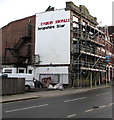
Missing letters on the side of former newspaper offices in Shrewsbury
Viewed across Chester Street on December 1st 2015. The building has been vacant since
Shrewsbury Chronicle and Shropshire Star staff relocated to new offices in Abbey Foregate in 2009.
Image: © Jaggery
Taken: 1 Dec 2015
0.02 miles
9
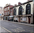
Albion Vaults, Shrewsbury
Pub at 12 Castle Foregate, opposite Shrewsbury railway station.
Image: © Jaggery
Taken: 16 Nov 2015
0.02 miles
10
Flooded Chester Street, Shrewsbury
This is a main thoroughfare in the town rendered impassable when the River Severn burst its banks after successive storms.
Image: © John Lucas
Taken: 24 Feb 2020
0.02 miles