1
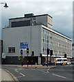
Cambrian House, Chester Street, Shrewsbury
A typical 1960s office block, with space available for rent.
Since this photo the building has been converted to flats and remodelled beyond recognition.
Image: © Stephen Richards
Taken: 16 May 2014
0.01 miles
2
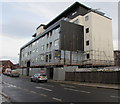
Cambrian House, Shrewsbury
Apartments on Chester Street.
Image: © JThomas
Taken: 14 Mar 2019
0.01 miles
3
Cambrian Business Centre, Shrewsbury
Office block dating from c1970, on the corner of Chester Street (on the right) and Cross Street.
The location is within a flood risk area near the River Severn. There are no offices on the ground floor where there is only the reception and plant room, which is protected by a flood barrier.
Image: © Jaggery
Taken: 31 May 2014
0.01 miles
4
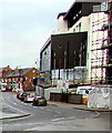
Scaffolding on Cambrian House, Shrewsbury
Viewed across Chester Street on December 1st 2015. In May 2015, the Shropshire Star reported that the former office block Cambrian House is being radically altered in a £3 million scheme which will see it transformed into 21 two and three bedroom apartments, including four penthouses. The building is being totally stripped back internally before being rebuilt and then reclad with a mixture of oak panelling, zinc and render.
Image: © Jaggery
Taken: 1 Dec 2015
0.01 miles
5
Railway Bridges
The railway forks here and the steel plate girder bridge in the foreground carries the line to Wrexham and Chester. The brick arch carries the line to Crewe.
Image: © Mike White
Taken: 9 Aug 2008
0.01 miles
6
Queueing at red lights in Chester Street, Shrewsbury
Cars on the A528 Chester Street.
Image: © Jaggery
Taken: 26 Nov 2015
0.01 miles
7
Shrewsbury - Crewe Junction signalbox
Image: © Peter Whatley
Taken: 12 Jul 2014
0.01 miles
8
Under railway lines towards Shrewsbury railway station
The A528 passes under railway lines immediately northwest of Shrewsbury railway station.
Image: © Jaggery
Taken: 1 Dec 2015
0.01 miles
9
Crewe Junction signal box
At the north end of Shrewsbury station, controls the routes to Crewe and Wrexham. It is one of four boxes surviving in the immediate Shrewsbury area, the others being Severn Bridge Junction, Sutton Bridge Junction and Abbey Foregate Junction.
Image: © John Lucas
Taken: 6 Jan 2016
0.02 miles
10
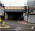
Low arch bridge 20 metres ahead, Cross Street, Shrewsbury
Yellow on black signs on both sides of Cross Street draw attention to the low arch bridge behind the bridge in view. The road ahead passes under a railway junction immediately NW of Shrewsbury station. The many tracks in the junction extend across about 40 metres.
Image: © Jaggery
Taken: 31 May 2014
0.02 miles


