IMAGES TAKEN NEAR TO
Kenneth Court, Dogpole, SHREWSBURY, SY1 1ET
Introduction
This page details the photographs taken nearby to Kenneth Court, Dogpole, SY1 1ET by members of the Geograph project.
The Geograph project started in 2005 with the aim of publishing, organising and preserving representative images for every square kilometre of Great Britain, Ireland and the Isle of Man.

There are currently over 7.5m images from over14,400 individuals and you can help contribute to the project by visiting https://www.geograph.org.uk
Image Map
Images are licensed for reuse under creativecommons.org/licenses/by-sa/2.0
Notes
- Clicking on the map will re-center to the selected point.
- The higher the marker number, the further away the image location is from the centre of the postcode.
Image Listing (1641 Images Found)
Images are licensed for reuse under creativecommons.org/licenses/by-sa/2.0
Image
Details
Distance
1
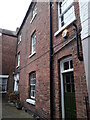
No 2 Dogpole Court, Shrewsbury
Along with the adjacent Image, no 2 Dogpole Court dates mainly from the early 19th century, although there are traces of an earlier building incorporated into the structure. It was Grade II listed https://britishlistedbuildings.co.uk/101247554-2-dogpole-court-shrewsbury#.YQWzzY5KjIU & https://historicengland.org.uk/listing/the-list/list-entry/1247554 in 1972.
Image: © Richard Law
Taken: 31 Jul 2021
0.00 miles
2
No 23 Dogpole, Shrewsbury
An early 19th century building, into which the ground-floor shopfront was inserted in the 20th. It was Grade II listed https://britishlistedbuildings.co.uk/101270852-23-dogpole-shrewsbury#.YQ56p4hKjIU & https://historicengland.org.uk/listing/the-list/list-entry/1270852 in 1972.
Image: © Richard Law
Taken: 31 Jul 2021
0.01 miles
3
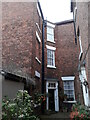
No 1 Dogpole Court, Shrewsbury
A hard place to photograph - it's tucked tightly into the far corner of a narrow courtyard, along with Image which is just visible here on the right. No 1 dates primarily from the early 19th century and is built of brick with a Welsh slate roof, although it apparently has traces of an earlier building in the lower part of the left-wing. It attracted a Grade II listing https://britishlistedbuildings.co.uk/101247173-1-dogpole-court-shrewsbury#.YQWybo5KjIU & https://historicengland.org.uk/listing/the-list/list-entry/1247173 in 1972.
Image: © Richard Law
Taken: 31 Jul 2021
0.01 miles
4
22 Dogpole, Shrewsbury
Built in the early 19th century as a house, but with later inserted shop premises below. The building was Grade II listed https://britishlistedbuildings.co.uk/101270998-22-dogpole-shrewsbury#.YZFYsWDP3IU & https://historicengland.org.uk/listing/the-list/list-entry/1270998 in 1972.
Image: © Richard Law
Taken: 14 Nov 2021
0.01 miles
5
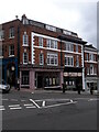
Nos 10 & 11 Wyle Cop, Shrewsbury
Nos 10 and 11 at the top of Wyle Cop were built at the beginning of the 19th century, and had shopfronts inserted around 1900. They were collectively Grade II listed https://britishlistedbuildings.co.uk/101254942-10-and-11-wyle-cop-shrewsbury#.YQ7_RIhKjIU & https://historicengland.org.uk/listing/the-list/list-entry/1254942 in 1972.
Image: © Richard Law
Taken: 31 Jul 2021
0.02 miles
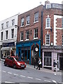
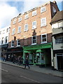
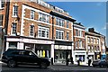
6
Teestar and Tootsies, Dogpole, Shrewsbury
Teestar on the left is a shoe shop at 22 Dogpole. Tootsies on the right,
on the corner of Wyle Cop, describes itself as a beauty retreat.
Image: © Jaggery
Taken: 31 May 2014
0.02 miles
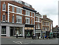
7
20 & 21 Wyle Cop, Shrewsbury
A late 18th century brick facade to the front of what's quite possible a late 17th century building, originally a house and now shops. They were Grade II listed https://britishlistedbuildings.co.uk/101255105-20-and-21-wyle-cop-shrewsbury#.XAOmBtSLTGg in 1972.
Image: © Richard Law
Taken: 19 Oct 2018
0.02 miles
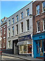
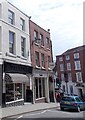
8
10-14 Wyle Cop, Shrewsbury
A run of quiet late C18th/early C19th buildings, the shopfronts inserted around a century later. Grade II listed.
Image: © Stephen Richards
Taken: 11 May 2014
0.02 miles
10
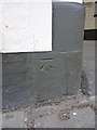
OS benchmark - The Lion Hotel
An OS benchmark at the entrance to the Lion Hotel on Wyle Cop, originally levelled at 63.994m (210' 9") above Ordnance Datum Newlyn.
Image: © Richard Law
Taken: 8 Mar 2014
0.02 miles