IMAGES TAKEN NEAR TO
Town Walls, SHREWSBURY, SY1 1AG
Introduction
This page details the photographs taken nearby to Town Walls, SY1 1AG by members of the Geograph project.
The Geograph project started in 2005 with the aim of publishing, organising and preserving representative images for every square kilometre of Great Britain, Ireland and the Isle of Man.

There are currently over 7.5m images from over14,400 individuals and you can help contribute to the project by visiting https://www.geograph.org.uk
Image Map
Images are licensed for reuse under creativecommons.org/licenses/by-sa/2.0
Notes
- Clicking on the map will re-center to the selected point.
- The higher the marker number, the further away the image location is from the centre of the postcode.
Image Listing (1577 Images Found)
Images are licensed for reuse under creativecommons.org/licenses/by-sa/2.0
Image
Details
Distance
1
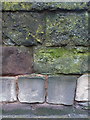
OS benchmark -Shrewsbury, Town Walls near telephone exchange
An OS cutmark on the Town Walls near the BT/GPO telephone exchange building; originally levelled at 59.515m above Ordnance Datum Newlyn.
Image: © Richard Law
Taken: 7 Jan 2017
0.00 miles
2
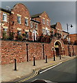
Bishopstone Mansions, Shrewsbury
Part of the street named Town Walls.
Image: © Jaggery
Taken: 15 Oct 2013
0.01 miles
3
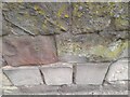
Ordnance Survey Cut Mark
This OS cut mark can be found on the Town Walls. It marks a point 59.515m above mean sea level.
Image: © Adrian Dust
Taken: 3 Jul 2023
0.02 miles
5
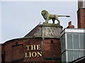
The back of the Lion Hotel, Shrewsbury
Image: © Marion Haworth
Taken: 24 Feb 2010
0.02 miles
6
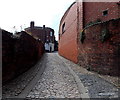
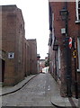
Up Belmont Bank, Shrewsbury
The lane ascends towards Sycamore House at 9 Belmont Bank.
Image: © Jaggery
Taken: 31 May 2014
0.02 miles
7
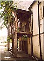
Screens passage of Nag's Head Hall, Wyle Cop, Shrewsbury
This is the only surviving part of a 14C hall-house, behind the nag's Head Inn. The roof is supported by a spere-truss, behind which is the screens passage on the ground floor with three service doorways.
Image: © Humphrey Bolton
Taken: 15 Sep 2001
0.02 miles
8
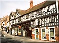
Building opposite the Lion Hotel, Wyle Cop, Shrewsbury
This building dates from c.1920, when the junction with Dogpole (the road up to the left seen in another photo), was widened. The shop front must be of that period, but the brick wall to the right looks out-of-place.
Image: © Humphrey Bolton
Taken: 15 Sep 2001
0.02 miles
9
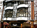
Shrewsbury - Boots
Probably the most unusual shopfront of any Boots.
Image: © David Barnes
Taken: 21 Aug 2002
0.02 miles
10
Belmont Bank, Shrewsbury
Viewed from Belmont. Belmont Mansions http://www.geograph.org.uk/photo/3886655 are on the left.
Image: © Jaggery
Taken: 15 Oct 2013
0.02 miles