1
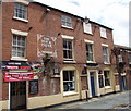
Former motorcycle shop, Shrewsbury
The shop unit on the corner of St Julian's Friars was empty when this photo was taken, but the fading sign on the wall makes its original function clear -"cycle & motorcycle tyres in stock - Velocette motorcycles - Lington cyclecars". That latter presumably refers to Lington of Bedford who made some early motorcars.
Image: © Stephen Craven
Taken: 20 Nov 2008
0.01 miles
2
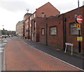
Car park entrance
A road running off Beeches Lane to the St Julians Friars car park. (Shrewsbury)
Image: © Richard Webb
Taken: 2 Aug 2016
0.01 miles
3
Flood defences at St Julian's Mews
The encroaching water is from the nearby River Severn.
Image: © Dave Croker
Taken: 13 Jan 2023
0.02 miles
4
Section of the medieval town wall off Beeches Lane
The sandstone wall on the left is a short stretch of the former Shrewsbury Town Wall, which was built from the 13th century onwards as a defensive structure. It's hard to access now that new houses have been built close up to it on the right, but the section a little further on from here, probably beyond the wooden shed, was Grade II listed https://britishlistedbuildings.co.uk/101271331-town-wall-to-south-of-numbers-3-10-shrewsbury#.Y2ZmOXbP3IU & https://historicengland.org.uk/listing/the-list/list-entry/1271331 in 1986 (the listing does not include the piece of the wall in this photo, rather oddly)
Image: © Richard Law
Taken: 30 Oct 2022
0.02 miles
5
Shrewsbury Telephone Exchange from the SE
The 5 storey building measures about 75 metres by 55 metres.
Image: © Jaggery
Taken: 15 Oct 2013
0.03 miles
6
West along Williams Way, Shrewsbury
Looking towards Shrewsbury Telephone Exchange. http://www.geograph.org.uk/photo/4000831
Image: © Jaggery
Taken: 15 Oct 2013
0.03 miles
7
The Corn House, Wyle Cop, Shrewsbury
This is a former corn warehouse and corn merchant's house now in use as restaurant. It was built c1850. It has iron framing internally, and cast-iron window frames. The recessed full-height arches with blue brick dressings are effective, and also the stepped corbelling to the gables. The door to the house is in the road to the side, St Julian's Friars, for that frontage see http://www.imagesofengland.org.uk/images/45/87/L458767.jpg
Image: © Humphrey Bolton
Taken: 15 Sep 2001
0.03 miles
8
Henry Tudor House, Wyle Cop, Shrewsbury
So called because he is reputed to have stayed here in 1485 before or after the Battle of Bosworth. The building is of the early 15C, and has the hall on the first floor. The traceried windows on that floor are original. The second floor is jettied out with coving in the overhang. The building to the left, Mytton's mansion, is also 15C.
Image: © Humphrey Bolton
Taken: 15 Sep 2001
0.03 miles
9
The Hop & Friar, Shrewsbury
Image: © Chris Whippet
Taken: 7 Jul 2011
0.03 miles
10
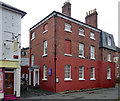
37 St Julian's Friars, Shrewsbury
Aka Sandford House. Built by local architect Joseph Bromfield for himself, c1800 according to the listing. He was also a plasterer and went to town inside. Grade II* listed.
Now the eponymous hotel.
Image: © Stephen Richards
Taken: 11 May 2014
0.03 miles


