IMAGES TAKEN NEAR TO
Whittington, OSWESTRY, SY11 4NT
Introduction
This page details the photographs taken nearby to SY11 4NT by members of the Geograph project.
The Geograph project started in 2005 with the aim of publishing, organising and preserving representative images for every square kilometre of Great Britain, Ireland and the Isle of Man.

There are currently over 7.5m images from over14,400 individuals and you can help contribute to the project by visiting https://www.geograph.org.uk
Image Map
Images are licensed for reuse under creativecommons.org/licenses/by-sa/2.0
Notes
- Clicking on the map will re-center to the selected point.
- The higher the marker number, the further away the image location is from the centre of the postcode.
Image Listing (4 Images Found)
Images are licensed for reuse under creativecommons.org/licenses/by-sa/2.0
Image
Details
Distance
1
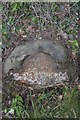
Old Milestone by the A495, Kinsale, Whittington parish
Metal plate attached to stone post by the A495, in parish of Whittington (Oswestry District), near Kinsale, by entrance to Kinsale Farm, on South side of road. Erected by the District Council in the 19th century.
Inscription reads:-
To
............M
Ellesmere 4
(Oswestry 4)
Shropshire HER.
HER Number (PRN): 21056 https://www.heritagegateway.org.uk/Gateway/Results_Single.aspx?uid=MSA23610&resourceID=1015
Milestone Society National ID: SA_ELOW04
Image: © A Reade/J Higgins
Taken: 30 Jul 2008
0.13 miles

3
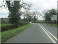
A495 at eastern entrance to Halston Hall
Just west of Kinsale
Image: © John Firth
Taken: 14 Apr 2012
0.18 miles
4
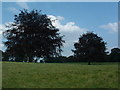
Shady trees, curiously sculpted
Two large trees in the grounds of Halston Hall, which appear to be a favoured foodstuff of the cows in the field. The foot of the trees are almost perfectly level at about 6 feet from the ground.
Image: © Alan Stewart
Taken: 29 Jun 2006
0.24 miles