IMAGES TAKEN NEAR TO
Burma Place, Burma Road, OSWESTRY, SY11 4FR
Introduction
This page details the photographs taken nearby to Burma Place, Burma Road, SY11 4FR by members of the Geograph project.
The Geograph project started in 2005 with the aim of publishing, organising and preserving representative images for every square kilometre of Great Britain, Ireland and the Isle of Man.

There are currently over 7.5m images from over14,400 individuals and you can help contribute to the project by visiting https://www.geograph.org.uk
Image Map (Loading...)


Getting Data...Please wait
Leaflet Map data © OpenStreetMap
Images are licensed for reuse under creativecommons.org/licenses/by-sa/2.0
Notes
- Clicking on the map will re-center to the selected point.
- The higher the marker number, the further away the image location is from the centre of the postcode.
Image Listing (5 Images Found)
Images are licensed for reuse under creativecommons.org/licenses/by-sa/2.0
Image
Details
Distance
1

The Venue, Park Hall
Events venue at the New Saints Football Club, who play in the Welsh League.
Image: © Eirian Evans
Taken: 15 Feb 2019
0.09 miles
2
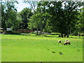
Sheep grazing
At Park Hall Farm, east of Oswestry.
Image: © John H Darch
Taken: 10 Aug 2021
0.17 miles
3
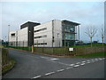
BT management centre building
Situated by the A495 near Oswestry.
Image: © Jonathan Billinger
Taken: 3 Jan 2008
0.23 miles
4

British Telecoms at Oswestry
BT's Worldwide Network Management Centre at Oswestry, opened on 5 September 1990
Image: © Eirian Evans
Taken: 15 Feb 2019
0.23 miles
5
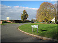
North Drive Inglis road junction
At Park Hall
Image: © John Firth
Taken: 10 Nov 2010
0.24 miles