IMAGES TAKEN NEAR TO
Whittington, OSWESTRY, SY11 4BD
Introduction
This page details the photographs taken nearby to SY11 4BD by members of the Geograph project.
The Geograph project started in 2005 with the aim of publishing, organising and preserving representative images for every square kilometre of Great Britain, Ireland and the Isle of Man.

There are currently over 7.5m images from over14,400 individuals and you can help contribute to the project by visiting https://www.geograph.org.uk
Image Map (Loading...)


Getting Data...Please wait
Leaflet Map data © OpenStreetMap
Images are licensed for reuse under creativecommons.org/licenses/by-sa/2.0
Notes
- Clicking on the map will re-center to the selected point.
- The higher the marker number, the further away the image location is from the centre of the postcode.
Image Listing (9 Images Found)
Images are licensed for reuse under creativecommons.org/licenses/by-sa/2.0
Image
Details
Distance
3

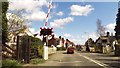
Level crossing at Whittington
On the edge of the village, the A495 road crosses the Shrewsbury to Chester railway line.
Image: © David Weston
Taken: 29 Oct 2019
0.08 miles
6
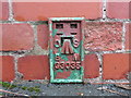
Ordnance Survey Flush Bracket G3035
This can be found on the wall of The Senior Citizens Hall in Whittington.
For more detail see : http://www.bench-marks.org.uk/bm15020
Image: © Peter Wood
Taken: 9 Dec 2016
0.23 miles
7
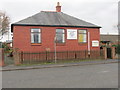
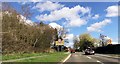
Whittington Senior Citizens Hall in Station Road (A495)
Looking southward.
Image: © Peter Wood
Taken: 9 Dec 2016
0.23 miles
8
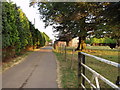
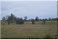
Farm Buildings at Drenewydd
A mix of traditional and modern buildings on this dairy farm.
Image: © John Haynes
Taken: 26 Jul 2006
0.23 miles
9
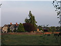
Farm house at Drenewydd
A large farmhouse with some farm buildings behind.
Image: © John Haynes
Taken: 26 Jul 2006
0.23 miles