IMAGES TAKEN NEAR TO
Willow Drive, OSWESTRY, SY11 3PS
Introduction
This page details the photographs taken nearby to Willow Drive, SY11 3PS by members of the Geograph project.
The Geograph project started in 2005 with the aim of publishing, organising and preserving representative images for every square kilometre of Great Britain, Ireland and the Isle of Man.

There are currently over 7.5m images from over14,400 individuals and you can help contribute to the project by visiting https://www.geograph.org.uk
Image Map
Images are licensed for reuse under creativecommons.org/licenses/by-sa/2.0
Notes
- Clicking on the map will re-center to the selected point.
- The higher the marker number, the further away the image location is from the centre of the postcode.
Image Listing (10 Images Found)
Images are licensed for reuse under creativecommons.org/licenses/by-sa/2.0
Image
Details
Distance

4
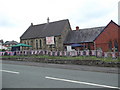
Preeshenlle URC church decked out for a summer fete
Image: © Eirian Evans
Taken: 11 Jun 2016
0.18 miles
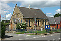
5
Preeshenlle United Reformed Church, Gobowen
Image: © John H Darch
Taken: 7 Feb 2021
0.19 miles
6
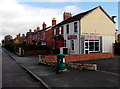
Taj Tandoori Indian takeaway, Gobowen
Located in St Martin's Road.
Image: © Jaggery
Taken: 16 Oct 2014
0.21 miles
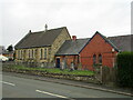
7
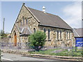
Preeshenlle United Reformed Church
A well maintained stone built church on the edge of Rhewl.
Image: © John Haynes
Taken: 12 Jul 2006
0.23 miles
8
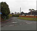
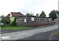
St David's Close, Gobowen
Viewed across Old Whittington Road.
Image: © Jaggery
Taken: 15 Sep 2014
0.23 miles
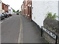
10
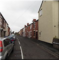
Old St Martin's Road, Gobowen
Viewed from the Old Whittington Road end looking towards By Pass Road.
Image: © Jaggery
Taken: 15 Sep 2014
0.24 miles