IMAGES TAKEN NEAR TO
Penybryn, St. Martins, OSWESTRY, SY11 3DT
Introduction
This page details the photographs taken nearby to SY11 3DT by members of the Geograph project.
The Geograph project started in 2005 with the aim of publishing, organising and preserving representative images for every square kilometre of Great Britain, Ireland and the Isle of Man.

There are currently over 7.5m images from over14,400 individuals and you can help contribute to the project by visiting https://www.geograph.org.uk
Image Map (Loading...)


Getting Data...Please wait
Leaflet Map data © OpenStreetMap
Images are licensed for reuse under creativecommons.org/licenses/by-sa/2.0
Notes
- Clicking on the map will re-center to the selected point.
- The higher the marker number, the further away the image location is from the centre of the postcode.
Image Listing (6 Images Found)
Images are licensed for reuse under creativecommons.org/licenses/by-sa/2.0
Image
Details
Distance
1
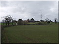
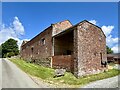
Rock Farm Buildings
Traditional set of buildings.
Image: © John Haynes
Taken: 12 Apr 2006
0.01 miles
4
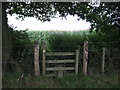
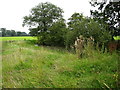
Stile on footpath
Near Rock Farm. The footpath was completely obscured by a tall Sweetcorn crop
Image: © Maggie Cox
Taken: 23 Aug 2013
0.12 miles
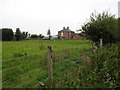
5
Pond in a field
From a single track road south of Rock Farm
Image: © Maggie Cox
Taken: 23 Aug 2013
0.23 miles
6
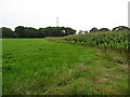
Field split between crops
Of sweetcorn and silage east of Rock Farm
Image: © Maggie Cox
Taken: 23 Aug 2013
0.25 miles