IMAGES TAKEN NEAR TO
Ellesmere Road, OSWESTRY, SY11 3BT
Introduction
This page details the photographs taken nearby to Ellesmere Road, SY11 3BT by members of the Geograph project.
The Geograph project started in 2005 with the aim of publishing, organising and preserving representative images for every square kilometre of Great Britain, Ireland and the Isle of Man.

There are currently over 7.5m images from over14,400 individuals and you can help contribute to the project by visiting https://www.geograph.org.uk
Image Map
Images are licensed for reuse under creativecommons.org/licenses/by-sa/2.0
Notes
- Clicking on the map will re-center to the selected point.
- The higher the marker number, the further away the image location is from the centre of the postcode.
Image Listing (6 Images Found)
Images are licensed for reuse under creativecommons.org/licenses/by-sa/2.0
Image
Details
Distance
4
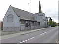
Methodist Chapel at St. Martins
Unusual for a Methodist chapel this building has a spire, albeit a small one. The 1940s map says that this is in Ifton Heath, but it is definitely after the modern sign for St. Martins.
Image: © John Haynes
Taken: 22 Oct 2005
0.19 miles
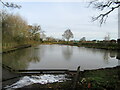
6
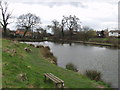
Fishing pond near to St Martins
A fishing pond fished by a local angling club.
Image: © John Haynes
Taken: 15 Mar 2007
0.20 miles